
Fil:Aleutians-space.jpg

Storleik på førehandsvising: 600 × 600 pikslar. Andre oppløysingar: 240 × 240 pikslar | 480 × 480 pikslar | 768 × 768 pikslar | 1 024 × 1 024 pikslar | 2 048 × 2 048 pikslar | 3 904 × 3 904 pikslar.
Opphavleg fil (3 904 × 3 904 pikslar, filstorleik: 10,69 MB, MIME-type: image/jpeg)
Følgjande er henta frå filomtalen åt denne fila på Wikimedia Commons:
Skildring
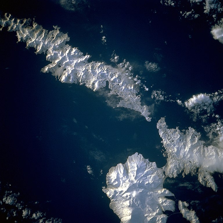
| Skildring | Aleutian Islands from space A photograph of Atka Island, Amlia Island, and other parts of the Aleutian chain, Alaska. Taken on the STS-56 shuttle mission, in April 1993. Image number: STS056-071-031 The oval, snow-covered northern peninsula of Atka Island, a cluster of severely eroded stratovolcanoes and caldera, is part of the Aleutian chain known as the Central Aleutian Islands. Korovin Volcano, near the northern edge of the island, has the highest elevation on the island [5030 feet (1533 meters)] and the most eruptive activity. Elongated, east-west-oriented Amlia Island to the east rises only 2100 feet (640 meters) at its highest elevation. |
| Dato | |
| Kjelde | http://eol.jsc.nasa.gov/sseop/EFS/lores.pl?PHOTO=STS056-71-31 |
| Opphavsperson | NASA |
| Kameraposisjon | | Dette og andre bilete på denne posisjonen i: OpenStreetMap |
|---|
This image or video was catalogued by one of the centers of the United States National Aeronautics and Space Administration (NASA) under Photo ID: STS056-71-31. This tag does not indicate the copyright status of the attached work. A normal copyright tag is still required. See Commons:Licensing. Other languages:
|
Lisensiering:
| This file is in the public domain in the United States because it was solely created by NASA. NASA copyright policy states that "NASA material is not protected by copyright unless noted". (See Template:PD-USGov, NASA copyright policy page or JPL Image Use Policy.) | ||
 |
Warnings:
|
Filhistorikk
Klikk på dato/klokkeslett for å sjå fila slik ho var på det tidspunktet.
| Dato/klokkeslett | Miniatyrbilete | Oppløysing | Brukar | Kommentar | |
|---|---|---|---|---|---|
| gjeldande | 26. august 2010 kl. 16:43 | | 3 904 × 3 904 (10,69 MB) | Originalwana | higher res |
| 5. desember 2004 kl. 00:52 |  | 639 × 639 (307 KB) | Mschlindwein | Aleutian Islands from space |
Filbruk
Den følgjande sida bruker denne fila:
Global filbruk
Desse andre wikiane nyttar fila:
- Bruk på en.wikipedia.org
- Bruk på es.wikipedia.org
- Bruk på gl.wikipedia.org
- Bruk på id.wikipedia.org
- Bruk på ms.wikipedia.org
- Bruk på pl.wikipedia.org
- Bruk på pt.wikipedia.org
- Bruk på ru.wikipedia.org
- Bruk på sh.wikipedia.org
- Bruk på sr.wikipedia.org
- Bruk på ta.wikipedia.org
- Bruk på uk.wikipedia.org
- Bruk på vi.wikipedia.org
- Bruk på zh.wikipedia.org