
Fil:EnglandLincolnshire.svg

Storleik på denne PNG-førehandsvisinga av denne SVG-fila: 200 × 247 pikslar. Andre oppløysingar: 194 × 240 pikslar | 389 × 480 pikslar | 622 × 768 pikslar | 829 × 1 024 pikslar | 1 658 × 2 048 pikslar.
Opphavleg fil (SVG-fil, standardoppløysing: 200 × 247 pikslar, filstorleik: 232 KB)
Følgjande er henta frå filomtalen åt denne fila på Wikimedia Commons:
Skildring
| Skildring |
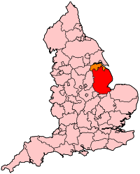
English: Map of Lincolnshire within England. |
| Kjelde | Eige arbeid |
| Opphavsperson | Wereon |
Lisensiering:
| Eg, opphavsrettshaldaren til dette verket, frigjev dette verket til ålmenta. Dette gjeld over heile verda. I somme landa er dette kan henda ikkje rettsleg mogeleg. I det fall: Eg gjev kven som helst rettane til å nytta dette verket for kva som helst føremål og utan vilkår, minder vilkår er kravde etter lova. |
Filhistorikk
Klikk på dato/klokkeslett for å sjå fila slik ho var på det tidspunktet.
| Dato/klokkeslett | Miniatyrbilete | Oppløysing | Brukar | Kommentar | |
|---|---|---|---|---|---|
| gjeldande | 22. april 2007 kl. 22:33 | | 200 × 247 (232 KB) | Wereon | Map of Lincolnshire within England. Category:Maps of counties of England |
Filbruk
Den følgjande sida bruker denne fila:
Global filbruk
Desse andre wikiane nyttar fila:
- Bruk på be.wikipedia.org
- Bruk på ce.wikipedia.org
- Bruk på cy.wikipedia.org
- Bruk på en.wikipedia.org
- Boston and Skegness (UK Parliament constituency)
- Gainsborough (UK Parliament constituency)
- Grantham and Stamford (UK Parliament constituency)
- Lincoln (UK Parliament constituency)
- Louth and Horncastle (UK Parliament constituency)
- Sleaford and North Hykeham (UK Parliament constituency)
- South Holland and The Deepings (UK Parliament constituency)
- Template:WikiProject UK geography
- Gainsborough and Horncastle (UK Parliament constituency)
- Talk:Borough of Bedford
- Talk:2009 structural changes to local government in England
- Template:WikiProject UK geography/sandbox
- Bonby Priory
- 2016 Sleaford and North Hykeham by-election
- Bruk på fr.wikipedia.org
- Bruk på hy.wikipedia.org
- Bruk på ko.wikipedia.org
- Bruk på pl.wikipedia.org
- Bruk på ru.wikipedia.org
- Bruk på th.wikipedia.org
- Bruk på uk.wikipedia.org
- Bruk på zh.wikipedia.org