
Fil:Europe biogeography countries en.svg

Storleik på denne PNG-førehandsvisinga av denne SVG-fila: 800 × 564 pikslar. Andre oppløysingar: 320 × 225 pikslar | 640 × 451 pikslar | 1 024 × 722 pikslar | 1 280 × 902 pikslar | 2 560 × 1 804 pikslar | 3 535 × 2 491 pikslar.
Opphavleg fil (SVG-fil, standardoppløysing: 3 535 × 2 491 pikslar, filstorleik: 710 KB)
Følgjande er henta frå filomtalen åt denne fila på Wikimedia Commons:
Skildring
| Skildring |
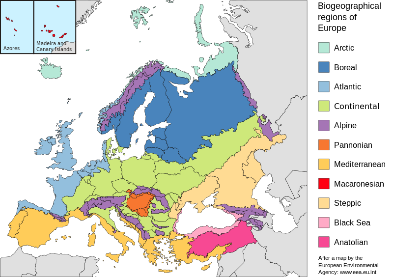
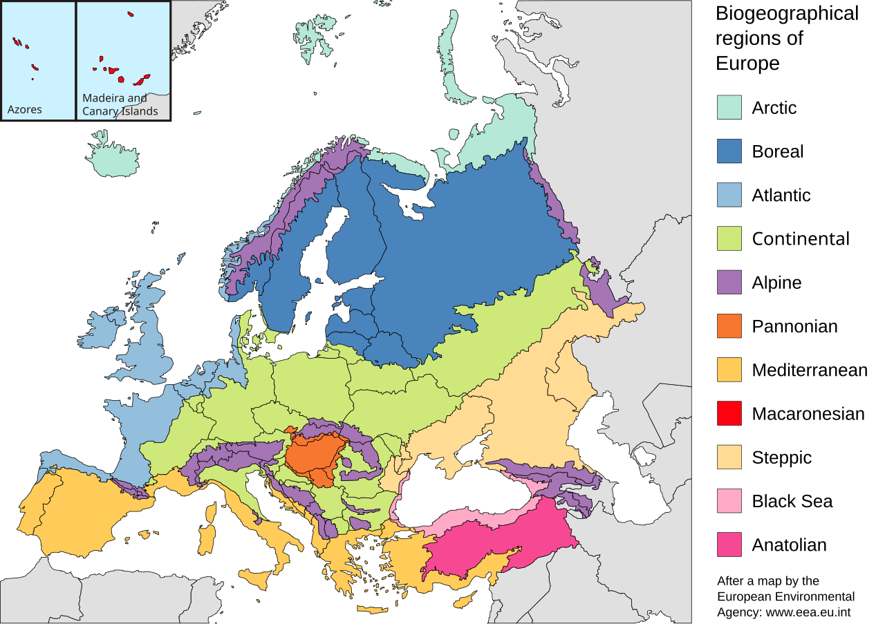
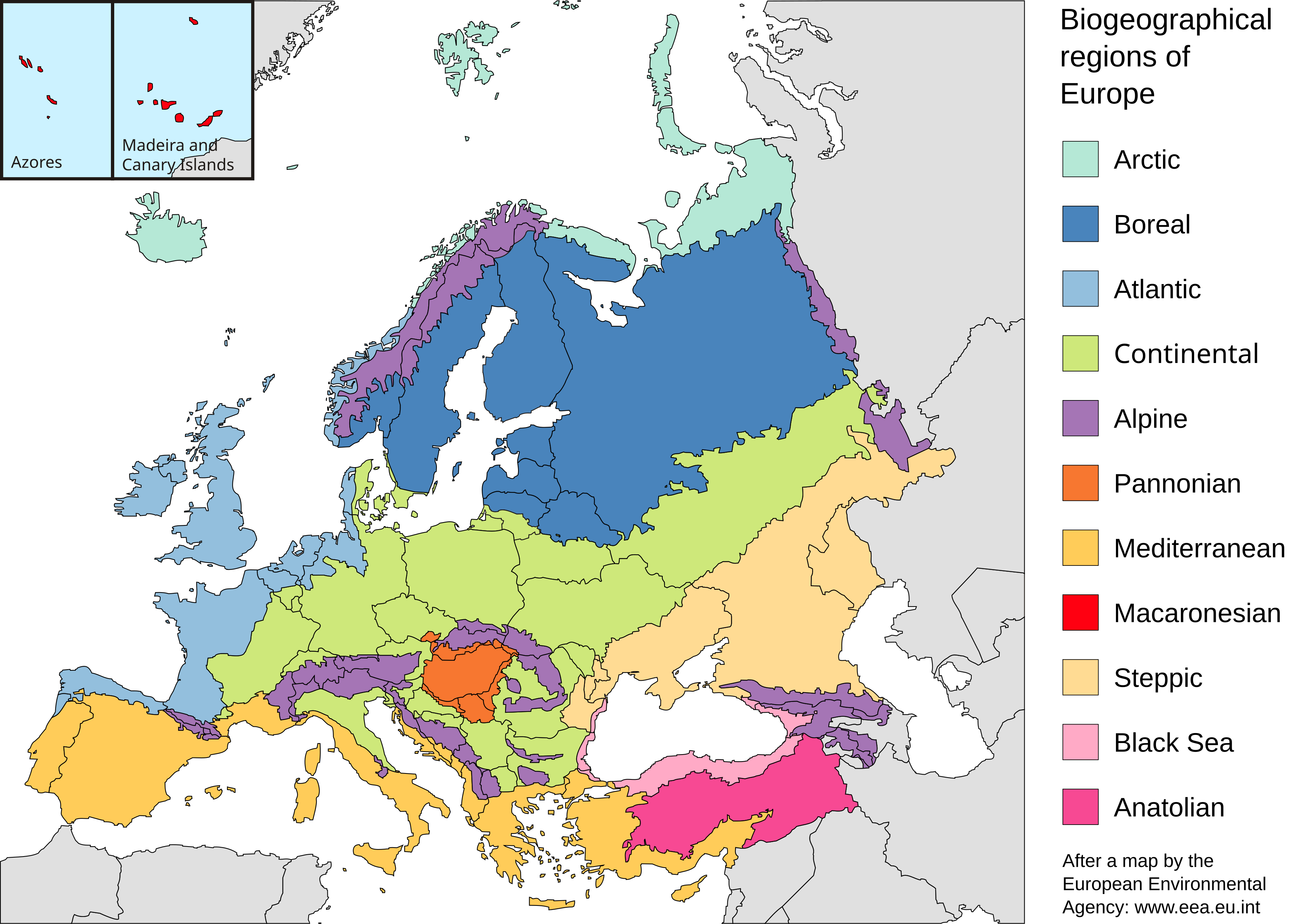
English: Map of the biogeographic regions of Europe, after EEA's map. Shows both country and biogeographical region boundaries. Legend in English. SVG format.
Español: Regiones biogeográficas de Europa.
Português: Regiões biogeográficas da Europa e regiões adjacentes.
한국어: Biogeographic regions. Biogeographic regions(Biogeographic regions.
Türkçe: Avrupa'nın Biyocoğrafik Bölgeleri (Türkiye'nin Asya kısmı da dahil).
Dansk: Pannonisk klima er her angivet med orange farve, der dækker dele af Slovakiet, Østrig, Serbien og Rumænien samt hele Ungarn.
Galego: Rexións bioxeográficas de Europa.
Norsk bokmål: Biogeografiske områder i Europa.
Norsk nynorsk: Biogeografiske område i Europa.
پښتو: Biogeographic regions of Europe.
Mirandés: Regiones biogeográficas de la Ouropa. |
| Dato | |
| Kjelde | Made with Inkscape from Image:Biogeographical Regions Europe - Map (intl).png by the European Environmental Agency |
| Opphavsperson | Júlio Reis |
| Andre versjonar |
Regions only: Image:Europe biogeography regions.svg; blank map: Image:Europe biogeography blank.svg  |
.png)
Lisensiering:
Denne fila er lisensiert under lisensen Creative Commons Namngjeving-DelPåSameVilkåra 3.0 Unported
- Du står fritt til å:
- til å dela – til å kopiera, distibuera og overføra arbeidet
- til å blanda – til å endra verket
- På desse vilkåra:
- namngjeving – Du lyt godskriva verket på den måten som opphavpersonen eller lisensgjevaren har oppgjeve (men ikkje på ein slik måte at det kan verka som om dei går god for deg eller måten du nyttar verket på).
- del på same vilkåra – Om du remiksar, omarbeider, eller på annan måte byggjer på dette verket, kan du berre distribuera resultatet under den same eller ein samsvarande lisens som denne.
Filhistorikk
Klikk på dato/klokkeslett for å sjå fila slik ho var på det tidspunktet.
| Dato/klokkeslett | Miniatyrbilete | Oppløysing | Brukar | Kommentar | |
|---|---|---|---|---|---|
| gjeldande | 19. juli 2010 kl. 22:41 | | 3 535 × 2 491 (710 KB) | Malus Catulus | Changed according graphic lab request: removed frame, hopefully fixed text, fixed some other stuff |
| 23. mai 2006 kl. 12:48 |  | 3 600 × 2 610 (876 KB) | Tintazul | {{Tintazul| |Description=Map of the biogeographic regions of Europe, after EEA's map. Shows both country and biogeographical region boundaries. Legend in English. SVG format. |Date=20 May 2006 |Source=Made with Inkscape from [[:Image:Biogeographical Regi |
Filbruk
Den følgjande sida bruker denne fila:
Global filbruk
Desse andre wikiane nyttar fila:
- Bruk på ar.wikipedia.org
- Bruk på azb.wikipedia.org
- Bruk på az.wikipedia.org
- Bruk på beta.wikiversity.org
- Bruk på bn.wikipedia.org
- Bruk på bs.wikipedia.org
- Bruk på cs.wikipedia.org
- Bruk på da.wikipedia.org
- Bruk på el.wikipedia.org
- Bruk på en.wikipedia.org
- Geography of Armenia
- Europe
- Biogeography
- Pannonian Basin
- Template talk:Greek diaspora
- User:Engram
- Fauna of Europe
- User:Whytecypress/UserboxCaucasian
- Portal:Maps/Maps/Geographic
- User talk:BadYodels
- Portal:Maps/Maps/Geographic/6
- User:Kaarel/sandbox/Fauna of Europe
- List of butterflies of Europe
- Mediterranean Biogeographic Region
- Arctic Biogeographic Region
- Boreal Biogeographic Region
- Biogeographic regions of Europe
- Atlantic Biogeographic Region
- Continental Biogeographic Region
- Anatolian Biogeographic Region
- Black Sea Biogeographic Region
- Macaronesian Biogeographic Region
- Alpine Biogeographic Region
- Pannonian Biogeographic Region
- Steppic Biogeographic Region
- Bruk på en.wikiversity.org
- Bruk på eo.wikipedia.org
- Bruk på es.wikipedia.org
- Bruk på fa.wikipedia.org
- Bruk på ga.wikipedia.org
- Bruk på gl.wikipedia.org
- Bruk på hy.wikipedia.org
- Bruk på ja.wikipedia.org
Sjå meir global bruk av denne fila.