
Fil:Eyalet of temesvar1699.png

Storleik på førehandsvising: 615 × 599 pikslar. Andre oppløysingar: 246 × 240 pikslar | 493 × 480 pikslar | 1 010 × 984 pikslar.
Opphavleg fil (1 010 × 984 pikslar, filstorleik: 113 KB, MIME-type: image/png)
Følgjande er henta frå filomtalen åt denne fila på Wikimedia Commons:
Skildring
| Skildring |
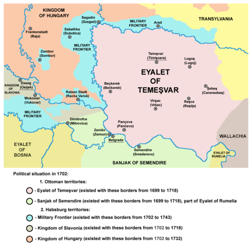
English: map of the Eyalet of Temesvar and Military Frontier in 1702.
Српски / srpski: мапа Темишварског пашалука и војне границе 1702. године. |
| Dato | 20. mars 2009 (original upload date) |
| Kjelde | Inga maskinlesbar kjelde er oppgjeven. Frå påstandar om opphavsrett vert det rekna med at det er eige arbeid. |
| Opphavsperson | Ingen maskinlesbar opphavsperson er oppgjeven. Frå påstandar om opphavsrett vert det rekna med at PANONIAN er opphavsperson. |
| Andre versjonar | Magyar svg |
References
- The Times History of Europe, Times Books, 2002.
- Školski istorijski atlas, Zavod za izdavanje udžbenika Socijalističke Republike Srbije, Beograd, 1970.
- Milan Tutorov, Banatska rapsodija - istorika Zrenjanina i Banata, Novi Sad, 2001.
- Peter Rokai - Zoltan Đere - Tibor Pal - Aleksandar Kasaš, Istorija Mađara, Beograd, 2002.
- Dr Dušan J. Popović, Srbi u Vojvodini, knjiga 2, Novi Sad, 1990.
- Fridrih Vilhelm fon Taube, Istorijski i geografski opis Kraljevine Slavonije i Vojvodstva Srema, Novi Sad, 1998.
- Miodrag Milin, Vekovima zajedno (Iz istorije srpsko-rumunskih odnosa), Temišvar, 1995.
- Suzana Milovanović, Potiska i pomoriška vojna granica (1702-1751), Novi Sad, 2003.
- Olga Zirojević, Srbija pod turskom vlašću 1459-1804, Beograd, 2007.
- Dr Dušan Popov, Granica i Graničari, Enciklopedija Novog Sada, sveska 6, Novi Sad, 1996.
- Orhan Kılıç, XVII. Yüzyılın İlk Yarısında Osmanlı Devleti'nin Eyalet ve Sancak Teşkilatlanması, Osmanlı, Cilt 6: Teşkilât, Yeni Türkiye Yayınları, Ankara, 1999.
- http://www.historiografija.hr/hz/1957/HZ_10_22_MATKOVIC.pdf archive copy at the Wayback Machine
- [1] - Historijski Zbornik, Том 10, Povijesno društro Hrvatske, 1957, page 215. ("da je Smederevski sandžak u razdoblju od 1591 — 1699 bio dio Budimskog pašaluka, od 1699 do 1791 dio Rumelij- skog pašaluka")
Lisensiering:
self made map by user:PANONIAN
| Eg, opphavsrettshaldaren til dette verket, frigjev dette verket til ålmenta. Dette gjeld over heile verda. I somme landa er dette kan henda ikkje rettsleg mogeleg. I det fall: Eg gjev kven som helst rettane til å nytta dette verket for kva som helst føremål og utan vilkår, minder vilkår er kravde etter lova. |
Filhistorikk
Klikk på dato/klokkeslett for å sjå fila slik ho var på det tidspunktet.
| Dato/klokkeslett | Miniatyrbilete | Oppløysing | Brukar | Kommentar | |
|---|---|---|---|---|---|
| gjeldande | 14. september 2013 kl. 23:11 | | 1 010 × 984 (113 KB) | PANONIAN | aesthetics |
| 5. september 2013 kl. 22:20 |  | 1 010 × 984 (117 KB) | PANONIAN | corrections | |
| 30. september 2011 kl. 18:59 |  | 1 015 × 984 (117 KB) | PANONIAN | correction | |
| 29. september 2011 kl. 14:42 |  | 1 015 × 984 (117 KB) | PANONIAN | some corrections | |
| 22. mars 2009 kl. 23:04 |  | 1 015 × 984 (120 KB) | PANONIAN | ||
| 20. mars 2009 kl. 14:02 |  | 1 015 × 936 (121 KB) | PANONIAN | ||
| 20. mars 2009 kl. 04:15 |  | 1 015 × 894 (111 KB) | PANONIAN | map of the Eyalet of Temesvar and Military Frontier in 1699 (self made) {{PD-self}} Category:Maps of the history of Romania Category:Maps of the history of Serbia Category:Maps of the history of Vojvodina |
Filbruk
Den følgjande sida bruker denne fila:
Global filbruk
Desse andre wikiane nyttar fila:
- Bruk på da.wikipedia.org
- Bruk på de.wikipedia.org
- Bruk på el.wikipedia.org
- Bruk på en.wikipedia.org
- Bruk på et.wikipedia.org
- Bruk på fa.wikipedia.org
- Bruk på gl.wikipedia.org
- Bruk på he.wikipedia.org
- Bruk på hr.wikipedia.org
- Bruk på ja.wikipedia.org
- Bruk på lt.wikipedia.org
- Bruk på mk.wikipedia.org
- Bruk på no.wikipedia.org
- Bruk på pnb.wikipedia.org
- Bruk på pt.wikipedia.org
- Bruk på ro.wikipedia.org
- Bruk på ru.wikipedia.org
- Bruk på sh.wikipedia.org
- Bruk på sk.wikipedia.org
- Bruk på sl.wikipedia.org
- Bruk på th.wikipedia.org
- Bruk på tr.wikipedia.org
- Bruk på tt.wikipedia.org
- Bruk på ur.wikipedia.org
- Bruk på vi.wikipedia.org