
Fil:Ga-map.png
Høgare oppløysing er ikkje tilgjengeleg.
Ga-map.png (631 × 319 pikslar, filstorleik: 12 KB, MIME-type: image/png)
Følgjande er henta frå filomtalen åt denne fila på Wikimedia Commons:
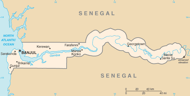
Skildring
| Skildring |
English: Map of Gambia |
| Dato | Ukjend dato |
| Kjelde | CIA World Factbook — https://www.cia.gov/library/publications/the-world-factbook/graphics/maps/ga-map.gif |
| Opphavsperson | Central Intelligence Agency |
Lisensiering:
Dette biletet er offentleg eigedom av di det inneheld tilfang som kjem frå Sambandsstatanes Central Intelligence Agency si Allkunnebok over verda.
|
 |
Filhistorikk
Klikk på dato/klokkeslett for å sjå fila slik ho var på det tidspunktet.
| Dato/klokkeslett | Miniatyrbilete | Oppløysing | Brukar | Kommentar | |
|---|---|---|---|---|---|
| gjeldande | 31. oktober 2021 kl. 02:30 | | 631 × 319 (12 KB) | Lojwe | Cropped < 1 % horizontally, 1 % vertically using CropTool with precise mode. |
| 7. oktober 2013 kl. 11:54 |  | 634 × 323 (13 KB) | Jahoe | version as of October 2013 | |
| 7. juni 2006 kl. 08:15 |  | 634 × 323 (11 KB) | Jed | ||
| 3. mars 2005 kl. 22:42 |  | 637 × 323 (12 KB) | Alfio | CIA map of Gambia |
Filbruk
Dei følgjande 2 sidene bruker denne fila:
Global filbruk
Desse andre wikiane nyttar fila:
- Bruk på als.wikipedia.org
- Bruk på ar.wikipedia.org
- Bruk på ast.wikipedia.org
- Bruk på azb.wikipedia.org
- Bruk på be-tarask.wikipedia.org
- Bruk på bg.wikipedia.org
- Bruk på bn.wikipedia.org
- Bruk på bs.wikipedia.org
- Bruk på ca.wikipedia.org
- Bruk på da.wikipedia.org
- Bruk på de.wikipedia.org
- Bruk på el.wikipedia.org
- Bruk på en.wikipedia.org
- The Gambia
- History of the Gambia
- List of cities in the Gambia
- User:Atamari
- Wildlife of the Gambia
- User:Anonymous101/Userboxes
- Template:User WikiProject Gambia
- User:Annatto
- Category:Populated places in the Gambia
- Module:Location map/data/Gambia/doc
- Wikipedia:WikiProject Gambia/Participants
- List of villages in the Gambia
- Alexander Grant (British Army officer)
- Wikipedia:Userboxes/WikiProjects/Regional/04
- Wikipedia:Userboxes/WikiProjects/alphabetical/12
- Category:WikiProject Gambia participants
- Module:Location map/data/Gambia
- Wikipedia:Userboxes/Location/Gambia
- Gambia–Senegal border
- User:Catjacket
- Bruk på en.wikinews.org
- Bruk på eo.wikipedia.org
- Bruk på es.wikipedia.org
Sjå meir global bruk av denne fila.