
Fil:Nansen Greenland Crossing Map.png

Storleik på førehandsvising: 550 × 599 pikslar. Andre oppløysingar: 220 × 240 pikslar | 626 × 682 pikslar.
Opphavleg fil (626 × 682 pikslar, filstorleik: 55 KB, MIME-type: image/png)
Følgjande er henta frå filomtalen åt denne fila på Wikimedia Commons:
Skildring
| Skildring |
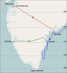
English: Map of Fridtjof Nansen's 1888 route across Greenland, the first crossing of the island.
Dotted line is the ship Jason's journey from Iceland to near Sermilik fjord (now known as Sermiligaaq), continuous blue line is the journey made by Nansen and his companions in two small boats trying to reach the coast. Planned journey from Sermilik northwest to Christianhaab (today known as Qasigiannguit). Nansen's actual journey across Greenland from Umivik fjord to Gothaab (today known as Nuuk). Deutsch: Die gepunktete Linie zeigt die Fahrt der Jason bis zum 17. Juli. Die durchgezogene Linie zeigt die Eisdrift bis zum 29. Juli und die Küstenwanderung bis zum 11. August. Die ursprünglich geplante Route von Sermilik nach Christianshåb. Die wirkliche Route vom 15. August bis 3. Oktober. |
| Dato | |
| Kjelde | Base map is File:Location map Greenland Southern.png, sea (blue) and land (green) journey lines based on File:NansenGreenlandrevisedMap.jpg, published 1888. Latitude lines based on Google Earth sateliite photos. |
| Opphavsperson | Base map is from OpenStreetMap by User:Dr. Blofeld, labels, latitude lines, and journey lines added by Ruhrfisch (talk) |
| Løyve (Gjenbruk av denne fila) |
GFDL, CC-BY-SA |
| Andre versjonar |
 |
Lisensiering:
Eg, opphavsrettshaldaren til verket, publiserer det hermed under desse lisensane:

|
Det er tillate å kopiera, distribuera og/eller modifisera dette dokumentet under retningslinene som er skildra i GNU fri dokumentasjonslisens, versjon 1.2 eller seinare utgåve utgjeven av Free Software Foundation; med alle seksjonane, utan nokon framsidetekstar og baksidetekstar. Ein kopi av lisensen er inkludert i avsnittet GNU Free Documentation License. |
This file is licensed under the Creative Commons Attribution-Share Alike 4.0 International, 3.0 Unported, 2.5 Generic, 2.0 Generic and 1.0 Generic license.
- Du står fritt til å:
- til å dela – til å kopiera, distibuera og overføra arbeidet
- til å blanda – til å endra verket
- På desse vilkåra:
- namngjeving – Du lyt godskriva verket på den måten som opphavpersonen eller lisensgjevaren har oppgjeve (men ikkje på ein slik måte at det kan verka som om dei går god for deg eller måten du nyttar verket på).
- del på same vilkåra – Om du remiksar, omarbeider, eller på annan måte byggjer på dette verket, kan du berre distribuera resultatet under den same eller ein samsvarande lisens som denne.
Du kan velje den lisensen du sjølv tykkjer er best.
Filhistorikk
Klikk på dato/klokkeslett for å sjå fila slik ho var på det tidspunktet.
| Dato/klokkeslett | Miniatyrbilete | Oppløysing | Brukar | Kommentar | |
|---|---|---|---|---|---|
| gjeldande | 7. august 2010 kl. 23:08 | | 626 × 682 (55 KB) | Ruhrfisch | Extend green line along fjord to Godthab, make blue line dotted at first. All other information is the same. |
| 7. august 2010 kl. 16:54 |  | 626 × 682 (55 KB) | Ruhrfisch | {{Information |Description= Map of Fridtjof Nansen's 1888 route across Greenland, the first crosing of the island. Ocean journey is blue, land journey is green, proposed original journey route is red. |Source= Base map is [[:File:Location map Greenland So |
Filbruk
Den følgjande sida bruker denne fila:
Global filbruk
Desse andre wikiane nyttar fila:
- Bruk på ba.wikipedia.org
- Bruk på be.wikipedia.org
- Bruk på bg.wikipedia.org
- Bruk på de.wikipedia.org
- Bruk på en.wikipedia.org
- Bruk på eo.wikipedia.org
- Bruk på es.wikipedia.org
- Bruk på fr.wikipedia.org
- Bruk på he.wikipedia.org
- Bruk på hr.wikipedia.org
- Bruk på hy.wikipedia.org
- Bruk på id.wikipedia.org
- Bruk på pt.wikipedia.org
- Bruk på ro.wikipedia.org
- Bruk på rue.wikipedia.org
- Bruk på ru.wikipedia.org
- Bruk på sl.wikipedia.org
- Bruk på ta.wikipedia.org
- Bruk på uk.wikipedia.org