
Fil:View of Ambley Wood south of Upton - geograph.org.uk - 23051.jpg
Høgare oppløysing er ikkje tilgjengeleg.
View_of_Ambley_Wood_south_of_Upton_-_geograph.org.uk_-_23051.jpg (507 × 372 pikslar, filstorleik: 26 KB, MIME-type: image/jpeg)
Følgjande er henta frå filomtalen åt denne fila på Wikimedia Commons:
Skildring
| Skildring |
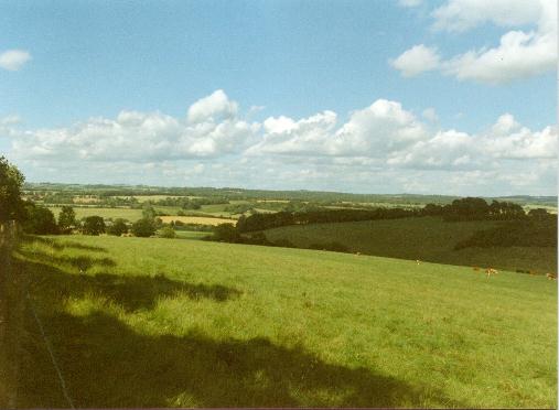
English: View of Ambley Wood south of Upton. This is a typical view of the chalk North Wessex Downs in the north west part of Hampshire. It is a scheduled Area of Outstanding Natural Beauty (AONB). Across the valley is what remains of Ambley Wood. Sheep and dairy farming is typical of the area though farming subsidies encourage cereal production. The small hamlet of Upton is to the left in the photo, hidden in the fold of the hill. |
| Dato | |
| Kjelde | From geograph.org.uk |
| Opphavsperson | Alan Cooper |
| Namngjeving (påkravd av lisensen) | Alan Cooper / View of Ambley Wood south of Upton / |
| Objektposisjon | | Dette og andre bilete på denne posisjonen i: OpenStreetMap |
|---|
_&language=nn)
Lisensiering:

|
This image was taken from the Geograph project collection. See this photograph's page on the Geograph website for the photographer's contact details. The copyright on this image is owned by Alan Cooper and is licensed for reuse under the Creative Commons Attribution-ShareAlike 2.0 license.
|
Denne filen er lisensiert under lisensen Creative Commons Navngivelse-DelPåSammeVilkår 2.0 Generisk
Namngjeving: Alan Cooper
- Du står fritt til å:
- til å dela – til å kopiera, distibuera og overføra arbeidet
- til å blanda – til å endra verket
- På desse vilkåra:
- namngjeving – Du lyt godskriva verket på den måten som opphavpersonen eller lisensgjevaren har oppgjeve (men ikkje på ein slik måte at det kan verka som om dei går god for deg eller måten du nyttar verket på).
- del på same vilkåra – Om du remiksar, omarbeider, eller på annan måte byggjer på dette verket, kan du berre distribuera resultatet under den same eller ein samsvarande lisens som denne.
- Remove redundant categories and try to put this image in the most specific category/categories
- Remove this template
- The location categories are based on information from this geonames tool and this OpenStreetMap tool combined with a database. You can also have a look at this tool from mysociety.
- The topic category from Geograph was Open countryside (find similar images countryside at Geograph)
Filhistorikk
Klikk på dato/klokkeslett for å sjå fila slik ho var på det tidspunktet.
| Dato/klokkeslett | Miniatyrbilete | Oppløysing | Brukar | Kommentar | |
|---|---|---|---|---|---|
| gjeldande | 30. januar 2010 kl. 07:44 | | 507 × 372 (26 KB) | GeographBot | == {{int:filedesc}} == {{Information |description={{en|1=View of Ambley Wood south of Upton. This is a typical view of the chalk North Wessex Downs in the north west part of Hampshire. It is a scheduled Area of Outstanding Natural Beauty (AONB). Across th |
Filbruk
Den følgjande sida bruker denne fila:
Global filbruk
Desse andre wikiane nyttar fila:
- Bruk på en.wikipedia.org
- Bruk på es.wikipedia.org
- Bruk på www.wikidata.org