
Fil:Vinson-Map.jpg

Storleik på førehandsvising: 626 × 599 pikslar. Andre oppløysingar: 251 × 240 pikslar | 501 × 480 pikslar | 802 × 768 pikslar | 1 070 × 1 024 pikslar | 2 139 × 2 048 pikslar | 3 207 × 3 070 pikslar.
Opphavleg fil (3 207 × 3 070 pikslar, filstorleik: 5,48 MB, MIME-type: image/jpeg)
Følgjande er henta frå filomtalen åt denne fila på Wikimedia Commons:
| Skildring |
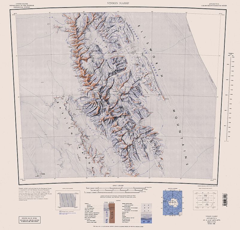
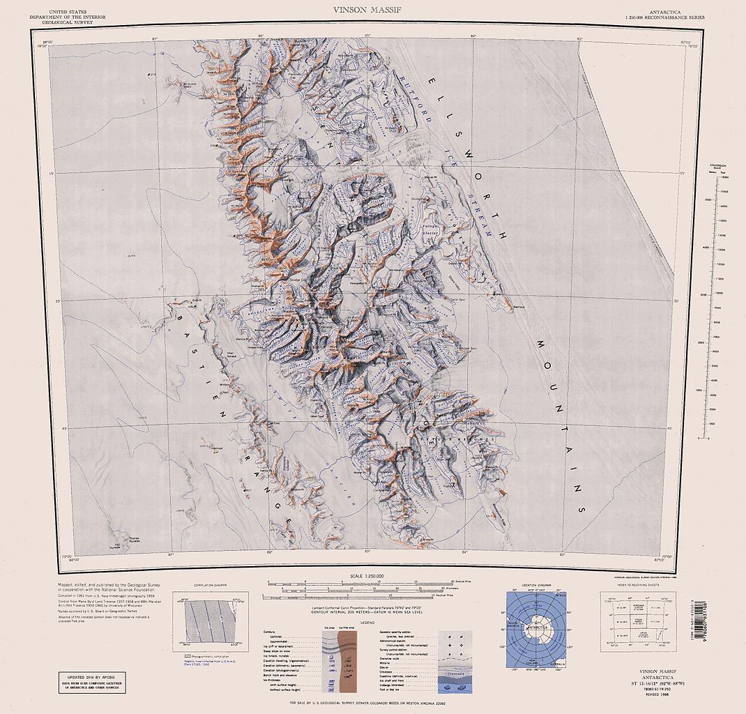
English: Map of Antarctica by the United States Antarctic Resource Center of the US Geological Survey (USGS). |
| Dato | |
| Kjelde | https://usarc.usgs.gov/drgs/dir1/c78082s1.jpg |
| Opphavsperson | United States Department of the Interior: Geological Survey |
| Andre versjonar |
Trimmed and updated version of Wikimedia Commons Image:C78082s1_Ant.Map_Vinson_Massif.jpg. |
This image is in the public domain in the United States because it only contains materials that originally came from the United States Geological Survey, an agency of the United States Department of the Interior. For more information, see the official USGS copyright policy.
|
Filhistorikk
Klikk på dato/klokkeslett for å sjå fila slik ho var på det tidspunktet.
| Dato/klokkeslett | Miniatyrbilete | Oppløysing | Brukar | Kommentar | |
|---|---|---|---|---|---|
| gjeldande | 22. januar 2014 kl. 18:25 | | 3 207 × 3 070 (5,48 MB) | Apcbg | Updated with data from SCAR Composite Gazetteer of Antarctica and other sources. |
| 27. august 2013 kl. 09:11 |  | 3 207 × 3 070 (5,47 MB) | Apcbg | Updated with data from SCAR Composite Gazetteer of Antarctica and other sources. | |
| 9. juli 2011 kl. 18:34 |  | 3 207 × 3 070 (5,46 MB) | Apcbg | Updated with data from SCAR Composite Gazetteer of Antarctica and other sources. | |
| 8. mars 2011 kl. 19:34 |  | 3 207 × 3 070 (5,47 MB) | Apcbg | Updated with data from SCAR Composite Gazetteer of Antarctica and other sources. | |
| 13. oktober 2010 kl. 18:52 |  | 3 207 × 3 070 (5,45 MB) | Apcbg | Updated with data from SCAR Composite Gazetteer of Antarctica and other sources. | |
| 30. januar 2007 kl. 12:27 |  | 3 207 × 3 070 (5,4 MB) | Apcbg | Map of Antarctica by the United States Antarctic Ressource Center of the US Geological Society. Trimmed version of Wikimedia image C78082s1_Ant.Map_Vinson_Massif.jpg {{PD-US}} Copyrights and Trademarks USGS-authored or produced data and information are |
Filbruk
Dei følgjande 50 sidene bruker denne fila:
- Arapyabreen
- Bagra Peak
- Bangey Heights
- Barnes Ridge
- Bastien Range
- Benderbreen
- Bolgradbreen
- Brookbreen
- Careybreen
- Craddock Massif
- Dramabreen
- Dropla Gap
- Ellsworth Mountains
- Flowers Hills
- Goodge Col
- Goreme Col
- Hammer Col
- Jacobsen Valley
- Johnson Col
- Johnson Spur
- Karnare Col
- Kasilag Pass
- Kornickerbreen
- Kostinbrod Pass
- Krusha Peak
- Lishness Peak
- Long Peak
- Manole Pass
- Mount Allen i Antarktis
- Mount Anderson i Antarktis
- Mount Craddock
- Mount Landolt
- Mount Liptak
- Mount Milton
- Mount Rutford
- Mount Strybing
- Nimitzbreen
- Owen Ridge
- Panicheri Gap
- Petvar Heights
- Probuda Ridge
- Remingtonbreen
- Sentinel Range
- Sirmabreen
- Vinson Massif
- Vinson Plateau
- Vranya Pass
- Wessbecherbreen
- Zinsmeister Ridge
- Zvegor Saddle
Global filbruk
Desse andre wikiane nyttar fila:
- Bruk på ar.wikipedia.org
- Bruk på ast.wikipedia.org
- Bruk på az.wikipedia.org
- Mirovyane zirvəsi
- Zimornitsa zirvəsi
- Fuça zirvəsi
- Bezden zirvəsi
- Oreşak zirvəsi
- Qolemani zirvəsi
- Marsa buzlağı
- Patleyna buzlağı
- Embree buzlağı
- Kopsis buzlağı
- Padala buzlağı
- Ellen buzlağı
- Fonfon buzlağı
- Gerila buzlağı
- Rumyana buzlağı
- Delyo buzlağı
- Burdenis buzlağı
- Arapya buzlağı
- Pulpudeva buzlağı
- Mamarçev zirvəsi
- Rutford
- Bruk på bg.wikipedia.org
- Bruk på ca.wikipedia.org
- Bruk på ceb.wikipedia.org
Sjå meir global bruk av denne fila.