Graptolite Island
| Graptolite Island | |||
| øy | |||
| Land | |||
|---|---|---|---|
| Øygruppe | Sør-Orknøyane | ||
| Koordinatar | 60°44′S 44°28′W / 60.733°S 44.467°W | ||
| Lengd | 0,9 km | ||
| Folketal | 0 | ||
| Administrert under | Antarktistraktaten | ||
 Graptolite Island 60°44′00″S 44°28′00″W / 60.7333°S 44.4667°W | |||
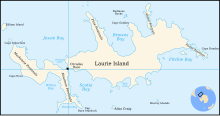
Graptolite Island er ei øy i den nordaustlege delen av Fitchie Bay, som ligg utanfor søraustdelen av Laurie Island i Sør-Orknøyane. James Weddell sitt kart frå 1825 syner to øyar på same stad. At det var ei enkel øy vart oppdaga i 1903 av Den skotske nasjonale antarktisekspedisjonen under William Speirs Bruce, som så namngav ho etter graptolittfossila som vart funnen der.[1]
Sjå òg[endre | endre wikiteksten]
Kjelder[endre | endre wikiteksten]
- ↑ «Graptolite Island». Geographic Names Information System. United States Geological Survey, United States Department of the Interior. Henta 22. oktober 2012.
![]() Denne artikkelen inneheld stoff som er offentleg eige frå United States Geological Survey-artikkelen «Graptolite Island» (innhald frå Geographic Names Information System).
Denne artikkelen inneheld stoff som er offentleg eige frå United States Geological Survey-artikkelen «Graptolite Island» (innhald frå Geographic Names Information System).


