
Fil:1748 Anson Map of Baja California and the Pacific with Trade Routes from Acapulco to Manila - Geographicus - Pacific-anson-1748.jpg
Storleik på førehandsvising: 800 × 402 pikslar. Andre oppløysingar: 320 × 161 pikslar | 640 × 322 pikslar | 1 024 × 515 pikslar | 1 280 × 643 pikslar | 2 560 × 1 287 pikslar | 5 000 × 2 513 pikslar.
Opphavleg fil (5 000 × 2 513 pikslar, filstorleik: 3,55 MB, MIME-type: image/jpeg)
Følgjande er henta frå filomtalen åt denne fila på Wikimedia Commons:
| A Chart of the Pacific Ocean from the Equinoctial to the Latitude fo 39 1/2 d. No. | ||||||
|---|---|---|---|---|---|---|
| Kunstnar | ||||||
| Tittel |
A Chart of the Pacific Ocean from the Equinoctial to the Latitude fo 39 1/2 d. No. |
|||||
| Skildring |
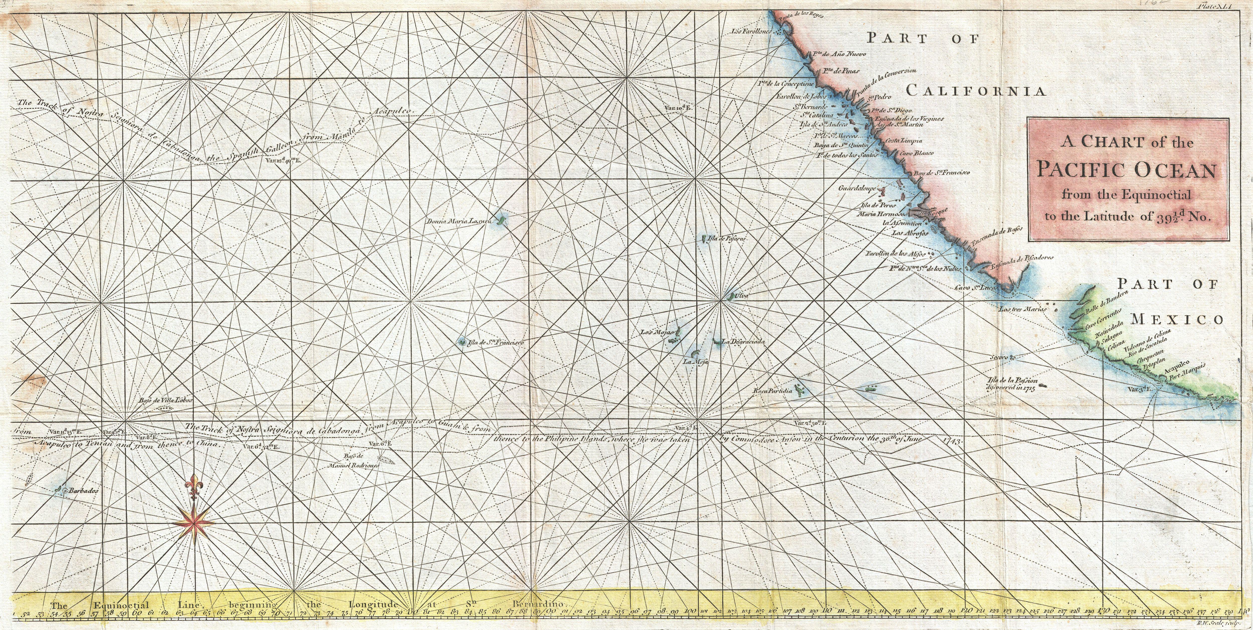
English: This is a rare 1748 nautical chart of the Pacific Ocean by George Anson and R. W. Seale. Chart depicts the trade routes used by Spanish Galleons from Acapulco, Mexico heading towards Manila in the Philippines. In particular, this chart depicts the travels of the Spanish Nostra Seigniora de Cabadonga and the British Navy Commodore George Anson. Anson lead an ill-equipped expedition into the Pacific with the mission to attack Spanish dominions in South America. Though he failed in this mission, Anson did succeed in capturing the Spanish treasure galleon off Cape Espiritu Santo on June 20, 1743. The Spanish galleon was loaded with gold, silver and, more importantly, nautical charts depicting the trade routes used by Spanish Galleons between Mexico and Manila for the previous 200 years. This significant discovery allowed the British to disrupt Spain’s trade in the Pacific and thus economically handicap the Spanish dominance of the New World. Following his capture of the Nostra, its treasures were paraded through the streets of London in no less than 32 wagons. Anson was hailed as a national hero. Beautifully details the Pacific Islands and much of the Mexican and California coast. Names numerous important destinations along the California coast including Cabo San Lucas, San Diego, and Acapulco. Rhumb lines throughout. Drawn by Seale and published as a supplement to the 1848 English edition of Anson’s important book A Voyage Round The World, In the Years MDCCXL, I, II, III, IV . |
|||||
| Dato | 1748 (undated) | |||||
| Dimensjonar | høgd: 11,5 in (29,2 cm); breidd: 22 in (55,8 cm) | |||||
| Museumsnummer |
Geographicus link: Pacific-anson-1748 |
|||||
| Kjelde/Fotograf |
Anson, George. A Voyage Round The World, In the Years MDCCXL, I, II, III, IV, (1748 English Editon).
|
|||||
| Løyve (Gjenbruk av denne fila) |
|
|||||
| Andre versjonar |
|
|||||
Filhistorikk
Klikk på dato/klokkeslett for å sjå fila slik ho var på det tidspunktet.
| Dato/klokkeslett | Miniatyrbilete | Oppløysing | Brukar | Kommentar | |
|---|---|---|---|---|---|
| gjeldande | 23. mars 2011 kl. 15:04 | | 5 000 × 2 513 (3,55 MB) | BotMultichillT | {{subst:User:Multichill/Geographicus |link=http://www.geographicus.com/P/AntiqueMap/Pacific-anson-1748 |product_name=1748 Anson Map of Baja California and the Pacific w/ Trade Routes from Acapulco to Manila |map_title=A Chart of the Pacific Ocean fro |
Filbruk
Den følgjande sida bruker denne fila: