
Fil:Airedale 1922 OS Map.png

Storleik på førehandsvising: 800 × 600 pikslar. Andre oppløysingar: 320 × 240 pikslar | 640 × 480 pikslar | 1 024 × 768 pikslar | 1 200 × 900 pikslar.
Opphavleg fil (1 200 × 900 pikslar, filstorleik: 2,53 MB, MIME-type: image/png)
Følgjande er henta frå filomtalen åt denne fila på Wikimedia Commons:
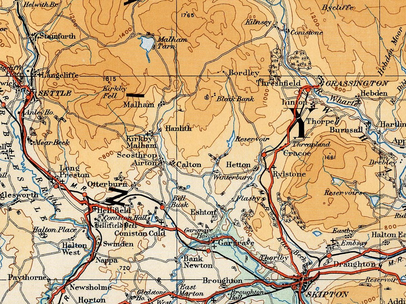
| Skildring | Map of the Airedale area taken from the 1922 Ordnance Survey Atlas of England and Wales |
| Dato | |
| Kjelde | http://www.guillemotdesign.org/maps/images/folio6left_300.jpg |
| Opphavsperson | JD554 |
Lisensiering:
This work is an Ordnance Survey map over 50 years old, which is covered by Crown Copyright which in this case expires 50 years after publication. Ordnance Survey does however ask that they be credited and that the date of publication be given.
Any ancillary rights gained through the creation of the electronic version are granted as freely usable under any circumstances.
|
This work created by the United Kingdom Government is in the public domain.
This is because it is one of the following:
HMSO has declared that the expiry of Crown Copyrights applies worldwide (ref: HMSO Email Reply)
|
 |
Filhistorikk
Klikk på dato/klokkeslett for å sjå fila slik ho var på det tidspunktet.
| Dato/klokkeslett | Miniatyrbilete | Oppløysing | Brukar | Kommentar | |
|---|---|---|---|---|---|
| gjeldande | 21. august 2008 kl. 15:54 | | 1 200 × 900 (2,53 MB) | JD554 | {{Information |Description=Map of the Airedale area taken from the 1922 Ordnance Survey Atlas of England and Wales |Source=http://www.guillemotdesign.org/maps/images/folio4left_300.jpg |Date=1922 |Author=JD554 |Permission=see below |other_versions= }} == |
Filbruk
Den følgjande sida bruker denne fila:
Global filbruk
Desse andre wikiane nyttar fila:
- Bruk på de.wikipedia.org
- Bruk på en.wikipedia.org
- Macrobert Arts Centre
- Birel
- Gillard (kart manufacturer)
- Kristina Cruises
- Lunn Poly
- Gola (manufacturer)
- Tenson (brand)
- Croker Oars
- Malham Tarn
- Six Continents
- Comedy Workshop
- Template:Leisure-company-stub
- HMSHost
- Magic Johnson Theatres
- Novak Electronics
- Movies@
- Copag
- Star Cinema (theater)
- Academy Music Group
- Great Planes Model Manufacturing
- Maxfli
- Zane's Cycles
- Consolidated Theatres (North Carolina)
- Thunder Tiger
- Planet Ice
- Grand Illusion Cinema
- Noise Fusion
- Big Monster Toys
- Richter (toy company)
- Exum Mountain Guides
- Eduard
- China Club
- Hammer Bowling
- Regatta (clothing)
- Mont Saint-Sauveur International
- Broadway Across Canada
- Goldvish
- Cicerones de Buenos Aires
- Olivia Travel
- Dolphin Cruise Lines
- MyOutdoorTV.com
- Ibero Cruises
- Scott Cinemas
- Reel Theatres
- Lowe Alpine
- User:Kjet/MSC
- Hong Thai Travel Services
- Shinkō Kinema
- Vango (company)
Sjå meir global bruk av denne fila.