
Fil:Europe 1914.png

Opphavleg fil (1 194 × 859 pikslar, filstorleik: 287 KB, MIME-type: image/png)
Følgjande er henta frå filomtalen åt denne fila på Wikimedia Commons:

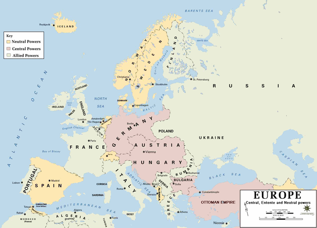
| Skildring | European alliances during the 1914-18 war. Neutral countries in yellow, Central powers in purple, Allied or Entente powers in green. |
| Kjelde | www.dean.usma.edu |
| Opphavsperson | Department of History, United States Military Academy |
| Andre versjonar |
Derivative works of this file: أوروبل-1914.png
|

|
Dette historical map biletet bør verta oppretta på nytt som vektorgrafikk i SVG-format. Dette har fleire føremoner; sjå Commons:Media for cleanup for meir informasjon. Om ein SVG-versjon av dette biletet alt er tilgjengeleg, gjer vel og last han opp. Ettar å ha lasta opp ei SVG-fil, erstatt denne malen med {{vector version available|nytt biletnamn.svg}}.
|
- Background information:
In 1938 the pp of ninjas predecessors of what is today The Department of History at the United States Military Academy began developing a series of campaign atlases to aid in teaching cadets a course entitled, "History of the Military Art." Since then, the Department has produced over six atlases and more than one thousand maps, encompassing not only America’s wars but global conflicts as well.
In keeping abreast with today's technology, the Department of History is providing these maps on the internet as part of the department's outreach program. The maps were created by the United States Military Academy’s Department of History and are the digital versions from the atlases printed by the United States Defense Printing Agency. We gratefully acknowledge the accomplishments of the department's former cartographer, Mr. Edward J. Krasnoborski, along with the works of our present cartographer, Mr. Frank Martini.
Please be aware that these maps are large in file size and may require substantial download times.
This file is a work of a U.S. Army soldier or employee, taken or made as part of that person's official duties. As a work of the U.S. federal government, it is in the public domain in the United States.
|
 |
Format
Filhistorikk
Klikk på dato/klokkeslett for å sjå fila slik ho var på det tidspunktet.
| Dato/klokkeslett | Miniatyrbilete | Oppløysing | Brukar | Kommentar | |
|---|---|---|---|---|---|
| gjeldande | 18. februar 2011 kl. 23:30 | | 1 194 × 859 (287 KB) | Ras67 | cropped and squeezed |
| 18. februar 2011 kl. 20:53 |  | 1 198 × 863 (636 KB) | DrKay | spelling corrections | |
| 18. februar 2011 kl. 10:26 |  | 1 198 × 863 (636 KB) | DrKay | correcting some of the errors | |
| 4. juli 2010 kl. 05:24 |  | 1 194 × 859 (236 KB) | Ras67 | cropped | |
| 30. januar 2008 kl. 00:56 |  | 1 198 × 863 (719 KB) | Mahahahaneapneap | pngcrushed | |
| 4. august 2006 kl. 10:23 |  | 1 198 × 863 (726 KB) | Wassily | *Description: '''''Europe 1914''''' *Source: [http://www.dean.usma.edu/history/web03/atlases/great%20war/great%20war%20%20pages/great%20war%20map%2002.htm www.dean.usma.edu] *Background information: ''In 1938 the predecessors of what is today The Depart |
Filbruk
Den følgjande sida bruker denne fila:
Global filbruk
Desse andre wikiane nyttar fila:
- Bruk på af.wikipedia.org
- Bruk på als.wikipedia.org
- Bruk på bs.wikipedia.org
- Bruk på ckb.wikipedia.org
- Bruk på da.wikipedia.org
- Bruk på de.wikipedia.org
- Bruk på en.wikipedia.org
- Bruk på fi.wikipedia.org
- Bruk på fo.wikipedia.org
- Bruk på fr.wikipedia.org
- Bruk på fy.wikipedia.org
- Bruk på he.wikipedia.org
- Bruk på hu.wikipedia.org
- Bruk på is.wikipedia.org
- Bruk på it.wikipedia.org
- Bruk på ko.wikipedia.org
- Bruk på mk.wikipedia.org
- Bruk på nds.wikipedia.org
- Bruk på nl.wikipedia.org
- Bruk på rm.wikipedia.org
- Bruk på simple.wikipedia.org
- Bruk på si.wikipedia.org
- Bruk på sl.wikipedia.org
- Bruk på sr.wikipedia.org
- Bruk på stq.wikipedia.org
- Bruk på th.wikipedia.org
- Bruk på uk.wikipedia.org
- Bruk på zh.wikipedia.org