
Fil:LocationComoros.png
Høgare oppløysing er ikkje tilgjengeleg.
LocationComoros.png (250 × 119 pikslar, filstorleik: 5 KB, MIME-type: image/png)
Følgjande er henta frå filomtalen åt denne fila på Wikimedia Commons:
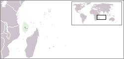
Locator map for the Comoros.
Originally created for English Wikipedia by Vardion.
| |
Dette verket er vorte frigjeve til ålmenta av opphavspersonen, Vardion på Wikimedia Commons. Dette gjeld over heile verda. I tilfeller hvor dette ikke er juridisk mulig: |

|
Ein vektorversjon av dette biletet (SVG) er tilgjengeleg.
Han bør verta nytta i staden for dette rasterbiletet der han er betre. File:LocationComoros.png → File:LocationComoros.svg
For meir informasjon om vektorgrafikk, les om overgangen til SVG på commons. Det finst òg informasjon om støtta MediaWiki har for SVG-bilete. |
 |
Filhistorikk
Klikk på dato/klokkeslett for å sjå fila slik ho var på det tidspunktet.
| Dato/klokkeslett | Miniatyrbilete | Oppløysing | Brukar | Kommentar | |
|---|---|---|---|---|---|
| gjeldande | 5. mars 2008 kl. 16:22 | | 250 × 119 (5 KB) | Panos84 | Location of the island nation of Comoros and its exclusive economic zone. |
| 12. desember 2004 kl. 01:00 |  | 250 × 115 (6 KB) | EugeneZelenko | Location map for the Comoros.<br/>Originally created for English Wikipedia by Vardion.<br/>{{PD}}<br/>Category:Country locator maps |
Filbruk
Dei følgjande 2 sidene bruker denne fila:
Global filbruk
Desse andre wikiane nyttar fila:
- Bruk på ar.wikipedia.org
- Bruk på bg.wikipedia.org
- Bruk på bpy.wikipedia.org
- Bruk på bs.wikipedia.org
- Bruk på ceb.wikipedia.org
- Bruk på de.wikinews.org
- Bruk på de.wiktionary.org
- Bruk på en.wikipedia.org
- Bruk på en.wikivoyage.org
- Bruk på en.wiktionary.org
- Bruk på eo.wikipedia.org
- Bruk på es.wikipedia.org
- Bruk på eu.wiktionary.org
- Bruk på frp.wikipedia.org
- Bruk på fr.wikipedia.org
- Bruk på fr.wiktionary.org
- Bruk på he.wikivoyage.org
- Bruk på hif.wikipedia.org
- Bruk på hr.wiktionary.org
- Bruk på hu.wikipedia.org
Sjå meir global bruk av denne fila.