
Fil:Lower slopes of Hermaness Hill, Unst.jpg
Høgare oppløysing er ikkje tilgjengeleg.
Lower_slopes_of_Hermaness_Hill,_Unst.jpg (640 × 479 pikslar, filstorleik: 45 KB, MIME-type: image/jpeg)
Følgjande er henta frå filomtalen åt denne fila på Wikimedia Commons:
| Kameraposisjon | | Dette og andre bilete på denne posisjonen i: OpenStreetMap |
|---|
_region:GB-GBN_heading:22.00&language=nn)
| Objektposisjon | | Dette og andre bilete på denne posisjonen i: OpenStreetMap |
|---|
_region:GB-GBN_heading:22.00&language=nn)

|
This image was taken from the Geograph project collection. See this photograph's page on the Geograph website for the photographer's contact details. The copyright on this image is owned by Bob Embleton and is licensed for reuse under the Creative Commons Attribution-ShareAlike 2.0 license.
|
Denne filen er lisensiert under lisensen Creative Commons Navngivelse-DelPåSammeVilkår 2.0 Generisk
Namngjeving: Bob Embleton
- Du står fritt til å:
- til å dela – til å kopiera, distibuera og overføra arbeidet
- til å blanda – til å endra verket
- På desse vilkåra:
- namngjeving – Du lyt godskriva verket på den måten som opphavpersonen eller lisensgjevaren har oppgjeve (men ikkje på ein slik måte at det kan verka som om dei går god for deg eller måten du nyttar verket på).
- del på same vilkåra – Om du remiksar, omarbeider, eller på annan måte byggjer på dette verket, kan du berre distribuera resultatet under den same eller ein samsvarande lisens som denne.
60:50.6829N 0:53.3210W
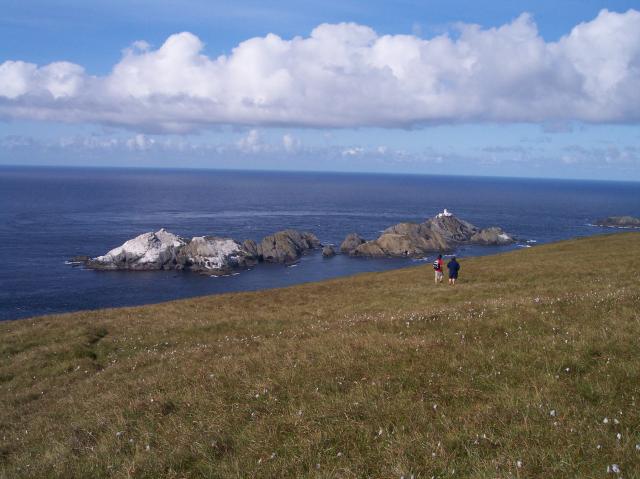
| Skildring |
Lower slopes of Hermaness Hill, Unst From left to right, which is also from south to north: Vesta Skerry, Rumblings, Tipta Skerry, Muckle Flugga (with the lighthouse), and at the righthand edge of the picture, Out Stack. Some smaller unnamed skerries in between. |
| Dato | |
| Kjelde | https://www.geograph.org.uk/photo/2131 |
| Opphavsperson | Bob Embleton |
Filhistorikk
Klikk på dato/klokkeslett for å sjå fila slik ho var på det tidspunktet.
| Dato/klokkeslett | Miniatyrbilete | Oppløysing | Brukar | Kommentar | |
|---|---|---|---|---|---|
| gjeldande | 30. mai 2007 kl. 01:26 | | 640 × 479 (45 KB) | Jorunn | {{geograph|2131|Bob Embleton}} 60:50.6829N 0:53.3210W {{Information |Description='''Lower slopes of Hermaness Hill, Unst'''<br> The most northerly point of the island of Unst looking out to The Skerries (in HP6019).<br>From left to right, which is also |
Filbruk
Dei følgjande 2 sidene bruker denne fila:
Global filbruk
Desse andre wikiane nyttar fila:
- Bruk på ceb.wikipedia.org
- Bruk på en.wikipedia.org
- Bruk på es.wikipedia.org
- Bruk på it.wikipedia.org
- Bruk på ru.wikipedia.org
- Bruk på sv.wikipedia.org
- Bruk på www.wikidata.org