
Fil:SWE-Map Combo2007CountyBorders.svg

Storleik på denne PNG-førehandsvisinga av denne SVG-fila: 266 × 600 pikslar. Andre oppløysingar: 106 × 240 pikslar | 213 × 480 pikslar | 340 × 768 pikslar | 454 × 1 024 pikslar | 908 × 2 048 pikslar | 290 × 654 pikslar.
Opphavleg fil (SVG-fil, standardoppløysing: 290 × 654 pikslar, filstorleik: 242 KB)
Følgjande er henta frå filomtalen åt denne fila på Wikimedia Commons:
| Skildring |
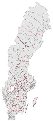
English: Municipalities and County borders of Sweden 2007. Note that Heby municipality now is part of Uppsala county. In this version the county borders are just a path lying on top of the municipality map. For info on how to easiest edit the map see SWE-Map Documentation
Svenska: Sveriges kommuner och länsgränser 2007. Notera att Heby kommun numera tillhör Uppsala län. I denna versionen är länsgränserna endast en linje som ligger ovanpå kommunkartan. För information om hur kartan lättast modifieras se SWE-Map Documentation |
| Dato | |
| Kjelde | Original borders of the map come from Statistics Sweden (SCB). The maps were edited and modified by Lokal_Profil. |
| Opphavsperson | Lokal_Profil |
| Løyve (Gjenbruk av denne fila) |
SCB allow free use (including commersial use and derivative work) of their maps ( ). This final result is licensed underDenne fila er lisensiert under lisensen Creative Commons Namngjeving-DelPåSameVilkåra 2.5 Generisk. Namngjeving: Lokal_Profil
|
| Andre versjonar |
|


Filhistorikk
Klikk på dato/klokkeslett for å sjå fila slik ho var på det tidspunktet.
| Dato/klokkeslett | Miniatyrbilete | Oppløysing | Brukar | Kommentar | |
|---|---|---|---|---|---|
| gjeldande | 16. april 2007 kl. 00:58 | | 290 × 654 (242 KB) | Lokal Profil | Inverted colours, reduced amount of white space on the sides and metadata cleanup |
| 12. april 2007 kl. 01:56 |  | 341 × 654 (238 KB) | Lokal Profil | {{Information |Description={{en|Municipalities and County borders of Sweden 2007. Note that Category:Heby municipality now is part of Uppsala county. In this version the county borders are just a path lying on top of the |
Filbruk
Dei følgjande 3 sidene bruker denne fila:
Global filbruk
Desse andre wikiane nyttar fila:
- Bruk på da.wikipedia.org
- Bruk på fi.wikipedia.org
- Bruk på ja.wikipedia.org
- Bruk på no.wikipedia.org