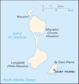
Fil:Saint Pierre and Miquelon map.gif
Saint_Pierre_and_Miquelon_map.gif (330 × 354 pikslar, filstorleik: 7 KB, MIME-type: image/gif)

Følgjande er henta frå filomtalen åt denne fila på Wikimedia Commons:
Filhistorikk
Klikk på dato/klokkeslett for å sjå fila slik ho var på det tidspunktet.
| Dato/klokkeslett | Miniatyrbilete | Oppløysing | Brukar | Kommentar | |
|---|---|---|---|---|---|
| gjeldande | 26. juni 2005 kl. 10:08 |  | 330 × 354 (7 KB) | Taichi | This is a map of Saint-Pierre and Miquelon from the CIA World Factbook (retrieved from http://www.cia.gov/cia/publications/factbook/geos/sb.html). According to the copyright notice on the website, all information of the World Factbook is in the public do |
Filbruk
Den følgjande sida bruker denne fila:
Global filbruk
Desse andre wikiane nyttar fila:
- Bruk på be-tarask.wikipedia.org
- Bruk på be.wikipedia.org
- Bruk på bn.wikipedia.org
- Bruk på ca.wikipedia.org
- Bruk på cs.wikipedia.org
- Bruk på dsb.wikipedia.org
- Bruk på el.wikipedia.org
- Bruk på en.wikipedia.org
- Bruk på eo.wikipedia.org
- Bruk på es.wikipedia.org
- Bruk på eu.wikipedia.org
- Bruk på fa.wikipedia.org
- Bruk på fi.wikipedia.org
- Bruk på fo.wikipedia.org
- Bruk på fr.wikipedia.org
- Bruk på hu.wikipedia.org
- Bruk på id.wikipedia.org
- Bruk på incubator.wikimedia.org
- Bruk på io.wikipedia.org
- Bruk på it.wikipedia.org
- Bruk på ja.wikipedia.org
- Bruk på kk.wikipedia.org
- Bruk på ko.wikipedia.org
- Bruk på ko.wiktionary.org
- Bruk på lt.wikipedia.org
- Bruk på mk.wikipedia.org
- Bruk på nl.wikipedia.org
- Bruk på no.wikipedia.org
- Bruk på os.wikipedia.org
- Bruk på pl.wikipedia.org
- Bruk på pl.wiktionary.org
Sjå meir global bruk av denne fila.


