
Fil:Schokalsky Bay, Antarctica.jpg
Schokalsky_Bay,_Antarctica.jpg (720 × 480 pikslar, filstorleik: 126 KB, MIME-type: image/jpeg)
Følgjande er henta frå filomtalen åt denne fila på Wikimedia Commons:
Skildring
| Skildring |
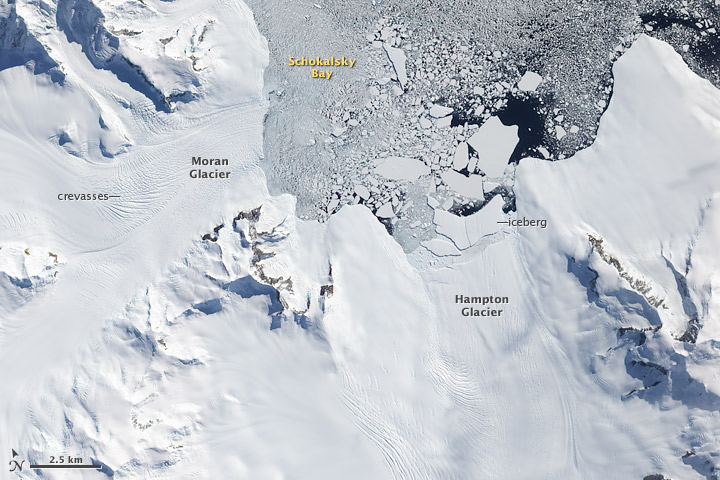
English: Few places on Earth have warmed more rapidly in recent decades than the Antarctic Peninsula, a narrow, mountainous spine of land that juts out from the continent into the Southern Ocean. More than 400 glaciers—often steep and heavily traced with crevasses—flow out of nearly every nook and cranny of the rugged peninsula, and the regional warming has caused the edges of many of these glaciers to retreat and their flow toward the ocean to accelerate. Faster flow of tidewater glaciers on the Antarctic Peninsula is adding directly to sea level rise.
This image of the northern tip of Alexander Island, near the western base of the Antarctic Peninsula, illustrates one of the processes through which glaciers can contribute to sea level rise: iceberg production. In this image, several large icebergs have calved from Hampton Glacier. Near the glacier, the bergs appear to be partially held in place by a mélange of ice that may include tiny iceberg fragments and frozen sea water. Farther out in Shokalsky Bay, the icebergs are floating more freely. Eventually, the bergs will drift northward to warmer waters, where they will melt. All glaciers that end in the ocean (called tidewater glaciers) periodically calve icebergs. When iceberg production is matched by snowfall accumulation on the glacier, the glacier is not contributing to sea level rise: all the water it adds to the ocean eventually returns to the glacier as snow. But if iceberg production (or a combination of iceberg production and melting) outpaces snowfall accumulation, then the glacier is contributing to sea level rise. Measuring the thickness and flow rates of glaciers on the Antarctic Peninsula is one of the objectives of an upcoming NASA aircraft campaign called Operation Ice Bridge. Beginning on October 12, 2009, and continuing for 6 weeks, NASA’s DC-8 research airplane and the Ice Bridge team scientists will make a series of flights from a base in southern Chile to collect observations over West Antarctica, the Antarctic Peninsula, and coastal areas where sea ice is prevalent. Each round-trip flight lasts about eleven hours, two-thirds of that time devoted to getting to and from Antarctica. References Pritchard, H.D., and Vaughan, D.G. (2007). Widespread acceleration of tidewater glaciers on the Antarctic Peninsula. Journal of Geophysical Research, 112, F03S29. |
| Dato | |
| Kjelde | http://earthobservatory.nasa.gov/IOTD/view.php?id=40629 |
| Opphavsperson | NASA image by Robert Simmon, using EO-1 ALI data provided courtesy of the NASA EO-1 team |
Lisensiering:
| This file is in the public domain in the United States because it was solely created by NASA. NASA copyright policy states that "NASA material is not protected by copyright unless noted". (See Template:PD-USGov, NASA copyright policy page or JPL Image Use Policy.) | ||
 |
Warnings:
|
Filhistorikk
Klikk på dato/klokkeslett for å sjå fila slik ho var på det tidspunktet.
| Dato/klokkeslett | Miniatyrbilete | Oppløysing | Brukar | Kommentar | |
|---|---|---|---|---|---|
| gjeldande | 27. februar 2012 kl. 10:30 | | 720 × 480 (126 KB) | 4ing | Cropped and labelled |
| 27. februar 2012 kl. 10:27 |  | 4 540 × 3 751 (3,62 MB) | 4ing |
Filbruk
Dei følgjande 6 sidene bruker denne fila:
Global filbruk
Desse andre wikiane nyttar fila:
- Bruk på ceb.wikipedia.org
- Bruk på de.wikipedia.org
- Bruk på en.wikipedia.org
- Bruk på es.wikipedia.org
- Bruk på fr.wikipedia.org
- Bruk på he.wikipedia.org
- Bruk på it.wikipedia.org
- Bruk på lld.wikipedia.org
- Bruk på uk.wikipedia.org
- Bruk på www.wikidata.org
- Bruk på zh.wikipedia.org