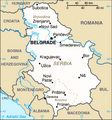
Fil:Serbia-CIA WFB Map 2006.png
Serbia-CIA_WFB_Map_2006.png (328 × 352 pikslar, filstorleik: 24 KB, MIME-type: image/png)

Følgjande er henta frå filomtalen åt denne fila på Wikimedia Commons:
Filhistorikk
Klikk på dato/klokkeslett for å sjå fila slik ho var på det tidspunktet.
| Dato/klokkeslett | Miniatyrbilete | Oppløysing | Brukar | Kommentar | |
|---|---|---|---|---|---|
| gjeldande | 15. juni 2017 kl. 20:03 |  | 328 × 352 (24 KB) | Кликери | Reverted to version as of 09:17, 20 June 2009 (UTC) |
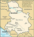
| 15. juni 2017 kl. 18:56 |  | 326 × 350 (33 KB) | Hakuli | Serbia map - CIA 2017 | |
| 20. juni 2009 kl. 11:17 |  | 328 × 352 (24 KB) | Mike Babic~commonswiki | {{Information |Description=CIA World Factbook map from 2006. It shows Kosovo as an autonomous province of Serbia. Kosovo declared itself independence on February 17, 2008. This is recognized by the United States and some other nations. The most recent | |
| 25. mars 2008 kl. 15:27 |  | 328 × 352 (16 KB) | Mattflaschen | {{Information |Description=CIA World Factbook map from 2006. It shows Serbia as an autonomous province of Serbia. Kosovo declared itself independence on February 17, 2008. This is recognized by the United States and some other nations. The most recent |
Filbruk
Det finst ikkje noka side som bruker denne fila.
Global filbruk
Desse andre wikiane nyttar fila:
- Bruk på ca.wikipedia.org
- Bruk på de.wikipedia.org
- Bruk på en.wikipedia.org
- Bruk på fa.wikipedia.org
- Bruk på hr.wikipedia.org
- Bruk på ja.wikipedia.org
- Bruk på mk.wikipedia.org
- Bruk på ms.wikipedia.org
- Ada (Serbia)
- Mol (Serbia)
- Obornjača (Ada)
- Utrine (Ada)
- Cerovac (Aerodrom)
- Aerodrom, Kragujevac
- Cvetojevac
- Čumić
- Desimirovac
- Donje Grbice
- Gornje Grbice
- Gornje Jarušice
- Jovanovac (Aerodrom)
- Lužnice (Aerodrom)
- Mali Šenj
- Mironić
- Novi Milanovac
- Opornica
- Pajazitovo
- Poskurice
- Resnik (Aerodrom)
- Šljivovac (Aerodrom)
- Aleksandrovac
- Bobote
- Boturići
- Dobroljubci
- Bratići
- Bzenice
- Dašnica (Aleksandrovac)
- Donja Zleginja
- Donje Rataje
- Donji Stupanj
- Donji Vratari
Sjå meir global bruk av denne fila.


