
Fil:Tajikistan Map TI-map.gif
Høgare oppløysing er ikkje tilgjengeleg.
Tajikistan_Map_TI-map.gif (636 × 325 pikslar, filstorleik: 29 KB, MIME-type: image/gif)
Følgjande er henta frå filomtalen åt denne fila på Wikimedia Commons:
Skildring
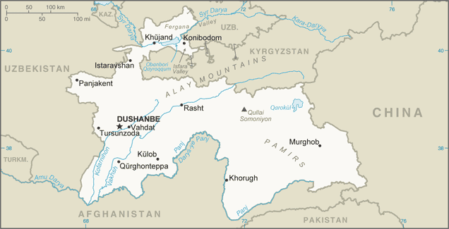
| Skildring |
English: Tajikistan Map (This version of the map includes significant changes from the previous version of the map including changes to the China-Tajikistan border.) |
| Dato | 2010-åra |
| Kjelde | [1] |
| Opphavsperson | CIA Factbook |
| Andre versjonar |
|

![[1]](https://www.cia.gov/library/publications/the-world-factbook/attachments/maps/TI-map.gif)
Lisensiering:
This work is in the public domain in the United States because it is a work prepared by an officer or employee of the United States Government as part of that person’s official duties under the terms of Title 17, Chapter 1, Section 105 of the US Code.
Note: This only applies to original works of the Federal Government and not to the work of any individual U.S. state, territory, commonwealth, county, municipality, or any other subdivision. This template also does not apply to postage stamp designs published by the United States Postal Service since 1978. (See § 313.6(C)(1) of Compendium of U.S. Copyright Office Practices). It also does not apply to certain US coins; see The US Mint Terms of Use.
|
 | |
| Denne fila er fastsett å vera fri for kjende avgrensingar under opphavsrettlovgjeving, medrekna alle relaterte og nærliggjande rettar. | ||
Filhistorikk
Klikk på dato/klokkeslett for å sjå fila slik ho var på det tidspunktet.
| Dato/klokkeslett | Miniatyrbilete | Oppløysing | Brukar | Kommentar | |
|---|---|---|---|---|---|
| gjeldande | 21. januar 2020 kl. 02:49 | | 636 × 325 (29 KB) | Geographyinitiative | User created page with UploadWizard |
Filbruk
Den følgjande sida bruker denne fila:
Global filbruk
Desse andre wikiane nyttar fila:
- Bruk på ar.wikipedia.org
- Bruk på ast.wikipedia.org
- Bruk på bg.wiktionary.org
- Bruk på bn.wikipedia.org
- Bruk på ca.wikipedia.org
- Bruk på cs.wikipedia.org
- Bruk på dsb.wikipedia.org
- Bruk på el.wikipedia.org
- Bruk på en.wikipedia.org
- Bruk på en.wiktionary.org
- Bruk på eo.wikinews.org
- Bruk på es.wikipedia.org
- Bruk på eu.wikipedia.org
- Bruk på fa.wikipedia.org
- Bruk på fr.wikipedia.org
- Bruk på gd.wikipedia.org
- Bruk på gl.wikipedia.org
- Bruk på ha.wikipedia.org
- Bruk på hif.wikipedia.org
- Bruk på hr.wikipedia.org
- Bruk på id.wikipedia.org
- Bruk på is.wikipedia.org
- Bruk på it.wikipedia.org
Sjå meir global bruk av denne fila.