
Hepburn i Northumberland
| Hepburn | |||
| busetnad | |||
 | |||
| Land | |||
|---|---|---|---|
| Fylke | Northumberland | ||
| Kommune | Tillside Parish | ||
 Hepburn i Northumberland 55°30′51″N 1°53′55″W / 55.51416667°N 1.89861111°W | |||
| Wikimedia Commons: Hepburn, Northumberland | |||
Hepburn er ei lite bygd og eit tidlegare sokn (civil parish) i Northumberland i England. Soknet blei slått saman med Chillingham i 1935.[1] Chillingham blei del av nylaga Tillside Parish i 2003.[2]
Hepburn ligg 5 mile (8,0 km) søraust for Wooler. I A Topographical Dictionary of England av Samuel Lewis frå 1848 blei staden oppgjeven å ha 108 innbyggjarar.[3] I Imperial Gazetteer of England and Wales av John Marius Wilson frå 1870-72 blei Hepburn eller Hebburn sagt å ha 19 hus og 77 innbyggjarar.[4] I 1951 hadde han 43 innbyggjarar.[5]
Hepburn Wood er ein skog i nærleiken, med Hepburn Crags som husar ei gammal bygdeborg.[6]
Hepburn Bastle er dei verna ruinane av eit befesta gardshus på staden.[7] Bygningen er omtalt frå 1500-talet. Han blei fråflytta på 1700-talet.[8]
-
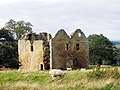 Hepburn Bastle
 -
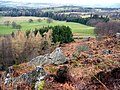 Utsyn frå Hepburn Crags
 -
 Hepburn Wood


Kjelder[endre | endre wikiteksten]
- ↑ «Relationships and changes Hepburn Tn/CP through time». Vision of Britain. Henta 1. februar 2018.
- ↑ «Tillside Civil Parish | Co-Curate», co-curate.ncl.ac.uk, henta 10. februar 2022
- ↑ «Hepburn, Northumberland | Co-Curate», co-curate.ncl.ac.uk, henta 10. februar 2022
- ↑ History of Hepburn, in Berwick upon Tweed and Northumberland. Map and description, A Vision of Britain through Time, GB Historical GIS / University of Portsmouth, henta 9. februar 2022
- ↑ «Population Statistics Naughton CP/AP through time». Vision of Britain. Henta 1. februar 2018.
- ↑ «Walking at Hepburn Wood», Forestry England (på engelsk), henta 10. februar 2022
- ↑ «Hepburn Bastle», castle-finders.co.uk, henta 10. februar 2022
- ↑ «Hepburn Bastle, Chillingham (The Gatehouse Record)», www.gatehouse-gazetteer.info, henta 10. februar 2022