
Fil:Map Bolivia territorial loss-en.jpg

Høgare oppløysing er ikkje tilgjengeleg.
Map_Bolivia_territorial_loss-en.jpg (471 × 447 pikslar, filstorleik: 56 KB, MIME-type: image/jpeg)
Følgjande er henta frå filomtalen åt denne fila på Wikimedia Commons:

|
Ein vektorversjon av dette biletet (SVG) er tilgjengeleg.
Han bør verta nytta i staden for dette rasterbiletet der han er betre. File:Map Bolivia territorial loss-en.jpg → File:Map Bolivia territorial loss-en.svg
For meir informasjon om vektorgrafikk, les om overgangen til SVG på commons. Det finst òg informasjon om støtta MediaWiki har for SVG-bilete. |
 |
Skildring
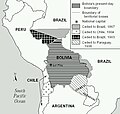
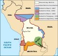
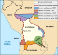
Taken from PDF file: http://lcweb2.loc.gov/frd/cs/bolivia/bo01_05a.pdf Converted by uploader The file is part of the Library of Congress Country Study on Bolivia
Other versions: []
-
 English (JPEG original)
 -
 English
 -
 español
 -
 français
 -
 magyar
 -
 македонски
 -
 српски / srpski


Lisensiering:
This work is in the public domain in the United States because it is a work prepared by an officer or employee of the United States Government as part of that person’s official duties under the terms of Title 17, Chapter 1, Section 105 of the US Code.
Note: This only applies to original works of the Federal Government and not to the work of any individual U.S. state, territory, commonwealth, county, municipality, or any other subdivision. This template also does not apply to postage stamp designs published by the United States Postal Service since 1978. (See § 313.6(C)(1) of Compendium of U.S. Copyright Office Practices). It also does not apply to certain US coins; see The US Mint Terms of Use.
|
 | |
| Denne fila er fastsett å vera fri for kjende avgrensingar under opphavsrettlovgjeving, medrekna alle relaterte og nærliggjande rettar. | ||
derivative works
Derivative works of this file: Map Bolivia territorial loss-en.svg
Filhistorikk
Klikk på dato/klokkeslett for å sjå fila slik ho var på det tidspunktet.
| Dato/klokkeslett | Miniatyrbilete | Oppløysing | Brukar | Kommentar | |
|---|---|---|---|---|---|
| gjeldande | 25. januar 2006 kl. 00:10 | | 471 × 447 (56 KB) | Bkwillwm | Category:Maps of Bolivia Category:LOC Wikiproject Taken from PDF file: http://lcweb2.loc.gov/frd/cs/bolivia/bo01_05a.pdf Converted by uploader The file is part of the Library of Congress Country Study on Bolivia |
Filbruk
Det finst ikkje noka side som bruker denne fila.
Global filbruk
Desse andre wikiane nyttar fila:
- Bruk på en.wikibooks.org
- Bruk på es.wikipedia.org
- Bruk på fr.wikipedia.org