
Fil:Cajas-National-Park Map.jpg

Storleik på førehandsvising: 703 × 600 pikslar. Andre oppløysingar: 281 × 240 pikslar | 563 × 480 pikslar | 900 × 768 pikslar | 1 201 × 1 024 pikslar | 2 401 × 2 048 pikslar | 2 653 × 2 263 pikslar.
Opphavleg fil (2 653 × 2 263 pikslar, filstorleik: 2,89 MB, MIME-type: image/jpeg)
Følgjande er henta frå filomtalen åt denne fila på Wikimedia Commons:
Skildring
| Skildring |
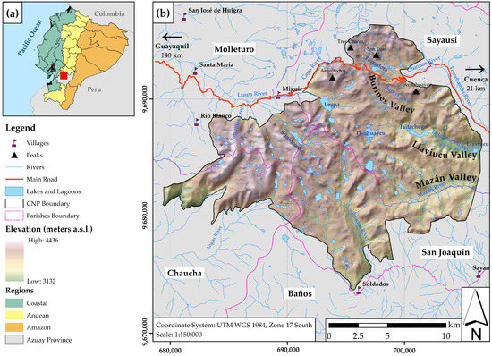
English: Location of Cajas National Park, Ecuador |
| Dato | |
| Kjelde |
Navarrete, Edison and Morante-Carballo, Fernando and Dueñas-Tovar, Jairo and Carrión-Mero, Paúl and Jaya-Montalvo, María and Berrezueta, Edgar (2022). «Assessment of Geosites within a Natural Protected Area: A Case Study of Cajas National Park». Sustainability 14. ISSN 2071-1050. doi:10.3390/su14053120 https://www.mdpi.com/2071-1050/14/5/3120# The file is a crop of https://www.mdpi.com/sustainability/sustainability-14-03120/article_deploy/html/images/sustainability-14-03120-g001-550.jpg |
| Opphavsperson | Navarrete, Edison and Morante-Carballo, Fernando and Dueñas-Tovar, Jairo and Carrión-Mero, Paúl and Jaya-Montalvo, María and Berrezueta, Edgar |
| Løyve (Gjenbruk av denne fila) |
Copyright: © 2022 Navarrete et al. All articles published by MDPI are made immediately available worldwide under an open access license. No special permission is required to reuse all or part of the article published by MDPI, including figures and tables. For articles published under an open access Creative Common CC BY license, any part of the article may be reused without permission provided that the original article is clearly cited. For more information, please refer to https://www.mdpi.com/openaccess. |
Lisensiering:
This file is licensed under the Creative Commons Attribution ShareAlike license, versions 1.0, 2.0, 2.5, 3.0, 4.0 and any later version released by Creative Commons. You may select the version of your choice. In short: you are free to share and make derivative works of the file under the conditions that you appropriately attribute it, and that you distribute it only under a license identical to this one. Official license: 1.0, 2.0, 2.5, 3.0, 4.0
|
Filhistorikk
Klikk på dato/klokkeslett for å sjå fila slik ho var på det tidspunktet.
| Dato/klokkeslett | Miniatyrbilete | Oppløysing | Brukar | Kommentar | |
|---|---|---|---|---|---|
| gjeldande | 16. juni 2023 kl. 22:50 | | 2 653 × 2 263 (2,89 MB) | Roarjo | =={{int:filedesc}}== {{Information |description={{en|Location of Cajas National Park, Ecuador}} |date=2022-03-07 |source=Navarrete, Edison and Morante-Carballo, Fernando and Dueñas-Tovar, Jairo and Carrión-Mero, Paúl and Jaya-Montalvo, María and Berrezueta, Edgar (2022). «Assessment of Geosites within a Natural Protected Area: A Case Study of Cajas National Park». Sustainability 14. ISSN 2071-1050. doi:10.3390/su14053120 https://www.mdpi.com/2071-1050/14/5/3120# <br/>The file is a crop of htt... |
Filbruk
Den følgjande sida bruker denne fila: