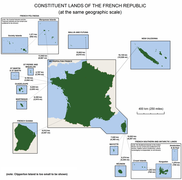
Fil:France-Constituent-Lands.png
Utsjånad

Storleik på førehandsvising: 606 × 599 pikslar. Andre oppløysingar: 243 × 240 pikslar | 485 × 480 pikslar | 777 × 768 pikslar | 1 035 × 1 024 pikslar | 2 071 × 2 048 pikslar | 3 337 × 3 300 pikslar.
Opphavleg fil (3 337 × 3 300 pikslar, filstorleik: 382 KB, MIME-type: image/png)

Følgjande er henta frå filomtalen åt denne fila på Wikimedia Commons:
Filhistorikk
Klikk på dato/klokkeslett for å sjå fila slik ho var på det tidspunktet.
| Dato/klokkeslett | Miniatyrbilete | Oppløysing | Brukar | Kommentar | |
|---|---|---|---|---|---|
| gjeldande | 7. november 2010 kl. 16:47 |  | 3 337 × 3 300 (382 KB) | Rosss | Moved French language map to a separate file |
| 6. september 2010 kl. 03:58 |  | 3 337 × 3 300 (299 KB) | Hypersite | Correction a few mistakes and showing of forgotten territories. -- Correction de petites erreurs et ajouts de territoires oublié. | |
| 17. april 2008 kl. 16:52 |  | 3 337 × 3 300 (382 KB) | Godefroy~commonswiki | {{Information |Description= The constituent lands of the French Republic |Source=self-made |Date= April 17, 2008 |Author= Godefroy |Permission= |other_versions= }} |
Filbruk
Den følgjande sida bruker denne fila:
Global filbruk
Desse andre wikiane nyttar fila:
- Bruk på an.wikipedia.org
- Bruk på ast.wikipedia.org
- Bruk på br.wikipedia.org
- Bruk på cs.wikipedia.org
- Bruk på de.wikipedia.org
- Bruk på en.wikipedia.org
- Bruk på en.wikibooks.org
- Bruk på es.wikipedia.org
- Bruk på et.wikipedia.org
- Bruk på eu.wikipedia.org
- Bruk på fa.wikipedia.org
- Bruk på fr.wikipedia.org
- Bruk på gl.wikipedia.org
- Bruk på he.wikipedia.org
- Bruk på hi.wikipedia.org
- Bruk på hy.wikipedia.org
- Bruk på id.wikipedia.org
- Bruk på ja.wikipedia.org
- Bruk på ka.wikipedia.org
- Bruk på km.wikipedia.org
- Bruk på lfn.wikipedia.org
- Bruk på lld.wikipedia.org
- Bruk på lv.wikipedia.org
- Bruk på ms.wikipedia.org
- Bruk på no.wikipedia.org
- Bruk på pdc.wikipedia.org
Sjå meir global bruk av denne fila.


