Fil:Hudson bay explorer.png

Sideinnhaldet er ikkje støtta på andre språk.
Frå Wikipedia – det frie oppslagsverket

Hudson_bay_explorer.png(550 × 442 pikslar, filstorleik: 449 KB, MIME-type: image/png)

Denne fila er frå Wikimedia Commons og kan verta nytta av andre prosjekt. Skildringa frå filskildringssida der er vist nedanfor.


Følgjande er henta frå filomtalen åt denne fila på Wikimedia Commons:


Skildring
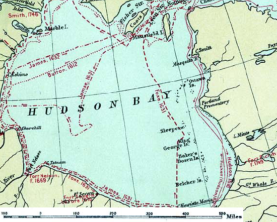
English: Map of the routes of the main European explorers in Hudson Bay, Canada.
Dato
Kjelde Excerpted from 1st Edition, 1906, Atlas of Canada - Routes of Explorers,1497 to 1905.
Opphavsperson Department of the Interior, Ottawa
Løyve
(Gjenbruk av denne fila)

Crown copyright expired.

Public domain
This Canadian work is in the public domain in Canada because its copyright has expired due to one of the following:
1. it was subject to Crown copyright and was first published more than 50 years ago, or

it was not subject to Crown copyright, and

2. it is a photograph that was created prior to January 1, 1949, or
3. the creator died prior to January 1, 1972.

For å kunne lagres på Commons må verket både være offentlig eiendom i USA og i opphavslandet. Vernetiden kan i noen tilfeller være lengre enn 80 år i USA, så i tillegg til dette merket trengs det et eget merke som forklarer hvorfor verket er offentlig eiendom (public domain) i USA. Note that this work might not be in the public domain in countries that do not apply the rule of the shorter term and have copyright terms longer than life of the author plus 50 years. In particular, Mexico is 100 years, Jamaica is 95 years, Colombia is 80 years, Guatemala and Samoa are 75 years, Switzerland and the United States are 70 years, and Venezuela is 60 years.


العربية  বাংলা  čeština  Deutsch  English  español  suomi  français  italiano  日本語  한국어  македонски  മലയാളം  Nederlands  português  português do Brasil  sicilianu  slovenščina  简体中文  繁體中文  +/−

Public domain
This work is in the public domain in the United States because it was published (or registered with the U.S. Copyright Office) before January 1, 1929.

Public domain works must be out of copyright in both the United States and in the source country of the work in order to be hosted on the Commons. If the work is not a U.S. work, the file must have an additional copyright tag indicating the copyright status in the source country.
Note: This tag should not be used for sound recordings.PD-1923Public domain in the United States//commons.wikimedia.org/wiki/File:Hudson_bay_explorer.png

Opphavleg opplastingslogg

The original description page was here. All following user names refer to en.wikipedia.
  • 2007-01-26 22:28 CyclePat 550×442×8 (459278 bytes) ==Description== This map shows the routes followed by the principal explorers of what is now Canada, from 1497 up to 1905. The map also shows the location of forts with the date of their establishment. It was created using [[:image:Canada, Routes of Explo

Bilettekstar

Skriv inn ei line med tekst som skildrar fila

Element som er med i denne fila

motiv

image/png

Filhistorikk

Klikk på dato/klokkeslett for å sjå fila slik ho var på det tidspunktet.

Dato/klokkeslettMiniatyrbileteOppløysingBrukarKommentar
gjeldande10. juli 2008 kl. 13:41Miniatyrbilete av versjonen frå 10. juli 2008 kl. 13:41550 × 442 (449 KB)Urdangaray{{Information |Description={{en|thumb|400px|right|Canada, Routes of Explorers,1497 to 1905 This map shows the routes followed by the principal explorers of what is now Canada, from 1497 up to 190

Den følgjande sida bruker denne fila:

Global filbruk

Desse andre wikiane nyttar fila: