
Fil:Iceland Mid-Atlantic Ridge map.svg

Storleik på denne PNG-førehandsvisinga av denne SVG-fila: 376 × 390 pikslar. Andre oppløysingar: 231 × 240 pikslar | 463 × 480 pikslar | 740 × 768 pikslar | 987 × 1 024 pikslar | 1 974 × 2 048 pikslar.
Opphavleg fil (SVG-fil, standardoppløysing: 376 × 390 pikslar, filstorleik: 129 KB)
Følgjande er henta frå filomtalen åt denne fila på Wikimedia Commons:
Skildring
| Skildring | |
| Dato | |
| Kjelde | http://pubs.usgs.gov/gip/dynamic/understanding.html |
| Opphavsperson | http://pubs.usgs.gov/gip/dynamic/understanding.html |
| Andre versjonar |
|


Lisensiering:
This image is in the public domain in the United States because it only contains materials that originally came from the United States Geological Survey, an agency of the United States Department of the Interior. For more information, see the official USGS copyright policy.
|
| Annotations | This image is annotated: View the annotations at Commons |
Filhistorikk
Klikk på dato/klokkeslett for å sjå fila slik ho var på det tidspunktet.
| Dato/klokkeslett | Miniatyrbilete | Oppløysing | Brukar | Kommentar | |
|---|---|---|---|---|---|
| gjeldande | 10. januar 2014 kl. 20:48 | | 376 × 390 (129 KB) | Amitchell125 | text improved |
| 26. februar 2010 kl. 16:42 |  | 376 × 390 (68 KB) | Beao | Tweak. | |
| 26. februar 2010 kl. 16:40 |  | 376 × 390 (68 KB) | Beao | Tweak. | |
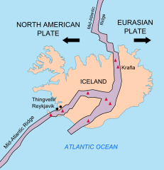
| 26. februar 2010 kl. 16:37 |  | 376 × 390 (68 KB) | Beao | == Summary == {{Information |Description={{en|1=Map showing the Mid-Atlantic Ridge splitting Iceland and separating the North American and Eurasian Plates. The map also shows Reykjavik, the capital of Iceland, the Thingvellir area, and the locations of so |
Filbruk
Det finst ikkje noka side som bruker denne fila.
Global filbruk
Desse andre wikiane nyttar fila:
- Bruk på be-tarask.wikipedia.org
- Bruk på bn.wikipedia.org
- Bruk på ca.wikipedia.org
- Bruk på en.wikipedia.org
- Bruk på en.wikivoyage.org
- Bruk på fi.wikipedia.org
- Bruk på hr.wikipedia.org
- Bruk på id.wikipedia.org
- Bruk på it.wikipedia.org
- Bruk på ko.wikipedia.org
- Bruk på lb.wikipedia.org
- Bruk på nl.wikipedia.org
- Bruk på no.wikipedia.org
- Bruk på pl.wikipedia.org
- Bruk på simple.wikipedia.org
- Bruk på sl.wikipedia.org
- Bruk på sr.wikipedia.org
- Bruk på sv.wikipedia.org
- Bruk på tr.wikipedia.org
- Bruk på uk.wikipedia.org
- Bruk på zh.wikipedia.org
- Bruk på zh.wikivoyage.org