
Fil:Remains of Nero's Isthmus Canal in 1881.jpg

Storleik på førehandsvising: 800 × 507 pikslar. Andre oppløysingar: 320 × 203 pikslar | 640 × 405 pikslar | 1 200 × 760 pikslar.
Opphavleg fil (1 200 × 760 pikslar, filstorleik: 225 KB, MIME-type: image/jpeg)
Følgjande er henta frå filomtalen åt denne fila på Wikimedia Commons:
Skildring
| Skildring |
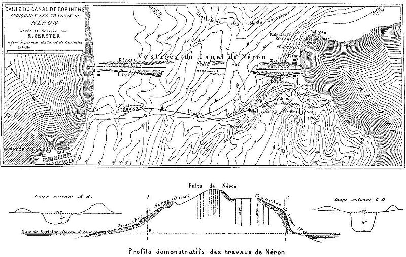
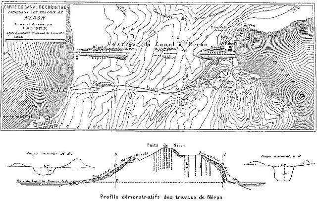
Deutsch: Überreste von Neros Projekt, einen Kanal durch den Isthmus von Korinth zu stechen (67 n. Chr.). Die dunkel schraffierten Bereiche markieren die antiken Aushubarbeiten. Die senkrechten Schächte im Bild unten dienten den Römern zur Begutachtung des Steinmaterials in der Tiefe. Die Karte wurde vom Chefingenieur des modernen Kanalprojekts Bela Gerster 1881 bei der Erkundung der Landenge angefertigt.
English: Remains of Nero's aborted project to cut through the Isthmus of Corinth (67 AD). The Roman digging is indicated by the dark shaded areas. The vertical shafts in the cross section below were excavated by the Romans to probe the stone material. The map was drawn by chief engineer Bela Gerster in 1881 during his survey for the modern canal. |
| Dato | |
| Kjelde | Werner, Walter: "The largest ship trackway in ancient times: the Diolkos of the Isthmus of Corinth, Greece, and early attempts to build a canal", The International Journal of Nautical Archaeology, Vol. 26, No. 2 (1997), pp. 98–119 (114, Fig. 25) |
| Opphavsperson | Bela Gerster (1850–1923) |
| Andre versjonar |
.jpg)

|
Dette old map biletet bør verta oppretta på nytt som vektorgrafikk i SVG-format. Dette har fleire føremoner; sjå Commons:Media for cleanup for meir informasjon. Om ein SVG-versjon av dette biletet alt er tilgjengeleg, gjer vel og last han opp. Ettar å ha lasta opp ei SVG-fil, erstatt denne malen med {{vector version available|nytt biletnamn.svg}}.
|


Lisensiering:
|
Dette verket er falt i det fri i Noreg, og dei landa som har opphavsrettsleg vernetid på 100 år etter opphavsmannen sin død, eller kortare. This work is in the public domain in the United States because it was published (or registered with the U.S. Copyright Office) before January 1, 1929. | |
| Denne fila er fastsett å vera fri for kjende avgrensingar under opphavsrettlovgjeving, medrekna alle relaterte og nærliggjande rettar. | |
Filhistorikk
Klikk på dato/klokkeslett for å sjå fila slik ho var på det tidspunktet.
| Dato/klokkeslett | Miniatyrbilete | Oppløysing | Brukar | Kommentar | |
|---|---|---|---|---|---|
| gjeldande | 15. januar 2008 kl. 18:46 | | 1 200 × 760 (225 KB) | Gun Powder Ma | == Summary == {{Information |Description= {{de| Überreste von Neros Projekt, einen Kanal durch den Isthmus von Korinth zu stechen. Die Karte wurde vom Chefingenieur des modernen Kanalprojekts Bela Gerster 1881 bei der Erkundung der Landenge gezeichnet. D |
| 15. januar 2008 kl. 18:38 |  | 751 × 476 (102 KB) | Gun Powder Ma | {{Information |Description= {{de| Überreste von Neros Projekt, einen Kanal durch den Isthmus von Korinth zu stechen. Die Karte wurde vom Chefingenieur des modernen Kanalprojekts Bela Gerster 1881 bei der Erkundung der Landenge gezeichnet. Die senkrechten |
Filbruk
Den følgjande sida bruker denne fila:
Global filbruk
Desse andre wikiane nyttar fila:
- Bruk på als.wikipedia.org
- Bruk på az.wikipedia.org
- Bruk på be.wikipedia.org
- Bruk på bg.wikipedia.org
- Bruk på da.wikipedia.org
- Bruk på de.wikipedia.org
- Bruk på en.wikipedia.org
- Bruk på es.wikipedia.org
- Bruk på et.wikipedia.org
- Bruk på fi.wikipedia.org
- Bruk på fr.wikipedia.org
- Bruk på hyw.wikipedia.org
- Bruk på it.wikipedia.org
- Bruk på no.wikipedia.org
- Bruk på ro.wikipedia.org
- Bruk på ru.wikipedia.org
- Bruk på sk.wikipedia.org
- Bruk på sl.wikipedia.org
- Bruk på sq.wikipedia.org
- Bruk på sv.wikipedia.org
- Bruk på tr.wikipedia.org
- Bruk på uk.wikipedia.org
- Bruk på vi.wikipedia.org