
Fil:SCO Map.png
Høgare oppløysing er ikkje tilgjengeleg.
SCO_Map.png (600 × 600 pikslar, filstorleik: 139 KB, MIME-type: image/png)
Følgjande er henta frå filomtalen åt denne fila på Wikimedia Commons:

|
Ein vektorversjon av dette biletet (SVG) er tilgjengeleg.
Han bør verta nytta i staden for dette rasterbiletet der han er betre. File:SCO Map.png → File:SCO (orthographic projection).svg
For meir informasjon om vektorgrafikk, les om overgangen til SVG på commons. Det finst òg informasjon om støtta MediaWiki har for SVG-bilete. |
.svg) |
| Skildring |
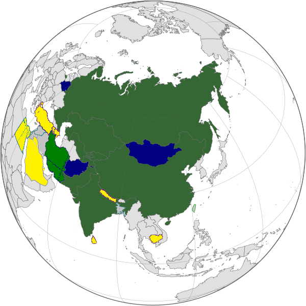
English: Map of the Shanghai Cooperation Organization.
Strict definition - Member states Broad definition: Chinese disputed territories, Observer states, Dialogue Partners Русский: Карта Шанхайской Организации Сотрудничества. Строгое определение - страны члены Широкое определение: Китайские спорные территории, страны наблюдатели, партнеры по диалогу |
||||||||
| Dato | 12. april 2005, updated on 20 June 2009 | ||||||||
| Kjelde | |||||||||
| Opphavsperson | Aris Katsaris, updated by Emilfaro | ||||||||
| Løyve (Gjenbruk av denne fila) |
|

Filhistorikk
Klikk på dato/klokkeslett for å sjå fila slik ho var på det tidspunktet.
| Dato/klokkeslett | Miniatyrbilete | Oppløysing | Brukar | Kommentar | |
|---|---|---|---|---|---|
| gjeldande | 20. september 2022 kl. 09:22 | | 600 × 600 (139 KB) | Yuri V. | correct version, without errors |
| 18. september 2017 kl. 13:07 |  | 600 × 600 (173 KB) | Hwatas | India and Pakistan | |
| 20. juni 2009 kl. 05:28 |  | 1 200 × 1 200 (367 KB) | Emilfaro | Orthographic projection. | |
| 16. juni 2009 kl. 14:48 |  | 1 567 × 692 (177 KB) | Honmingjun | Change the color of Taiwan | |
| 8. februar 2009 kl. 13:41 |  | 1 567 × 692 (218 KB) | Emilfaro | Based on SVG. | |
| 25. oktober 2008 kl. 08:25 |  | 1 425 × 625 (34 KB) | KAVO | {{Information |Description= |Source= |Date= |Author= |Permission= |other_versions= }} | |
| 22. oktober 2008 kl. 14:37 |  | 1 425 × 625 (58 KB) | Emilfaro | Turkmenistan color changed. | |
| 22. oktober 2008 kl. 14:35 |  | 1 425 × 625 (31 KB) | Emilfaro | Sorry, Turkmenistan is still CIS, thus a Guest Attendance. | |
| 18. oktober 2008 kl. 20:39 |  | 1 425 × 625 (31 KB) | Emilfaro | Turkmenistan was included by mistake. | |
| 18. oktober 2008 kl. 20:15 |  | 1 425 × 625 (31 KB) | Emilfaro | Global map as the alliance is large. |
Filbruk
Det finst ikkje noka side som bruker denne fila.
Global filbruk
Desse andre wikiane nyttar fila:
- Bruk på da.wikipedia.org
- Bruk på en.wikipedia.org
- Bruk på es.wikipedia.org
- Bruk på fr.wikinews.org
- Bruk på simple.wikipedia.org
- Bruk på zh.wikipedia.org