Fil:Stryi and Upper Dneistr Rivers.PNG

Sideinnhaldet er ikkje støtta på andre språk.
Frå Wikipedia – det frie oppslagsverket

Opphavleg fil(631 × 648 pikslar, filstorleik: 63 KB, MIME-type: image/png)

Denne fila er frå Wikimedia Commons og kan verta nytta av andre prosjekt. Skildringa frå filskildringssida der er vist nedanfor.


Følgjande er henta frå filomtalen åt denne fila på Wikimedia Commons:


Skildring

Skildring
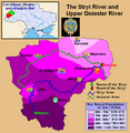
English: This is a map showing the Upper Dniestr River Basin, including its main tributary, the Stryi River, in the southwestern half of the Lviv Oblast in western Ukraine. It also shows the average annual precipitation by millimeters and inches for the region, and places the administrative centers of each of the raions in this area on the map. It includes and inset indicating where this is in relation to the rest of Ukraine, and provides the names of the closest villages to the Stryi River's head and mouth. I created this map, using Microsoft Paint, version 7.0, and borrowing data from Google Earth, and the 21st European Regional Conference 2005 - 15-19 May 2005 - Frankfurt (Oder) and Slubice - Germany and Poland report on "Floods Modeling in the Upper Dnister River Valley", by Ivan Kovalchuk, Andriy Mykhnovych, Volker Ehlert, Jörg Steidl, in conjunction with the Leibniz Centre for Agricultural Landscape Research (ZALF), Germany, and held at the Ivan Franko National University of L’viv, Ukraine, page4. URL: http://www.zalf.de/icid/ICID_ERC2005/HTML/ERC2005PDF/Topic_2/Kovalchuk.pdf
Dato 10. februar 2010 (original upload date)
Kjelde Transferred from en.wikipedia to Commons by SreeBot.
Opphavsperson Saukkomies at engelsk Wikipedia

Lisensiering:

Public domain Dette verket er vorte frigjeve til ålmenta av opphavspersonen, Saukkomies at engelsk Wikipedia. Dette gjeld over heile verda.
I somme landa er dette kan henda ikkje rettsleg mogeleg. I det fall:
Saukkomies gjev kven som helst rettane til å nytta dette verket for kva som helst føremål og utan vilkår, minder vilkår er kravde etter lova.

Opphavleg opplastingslogg

The original description page was here. All following user names refer to en.wikipedia.

Upload date | User | Bytes | Dimensions | Comment

  • 2010-02-10 01:12 (UTC) | Saukkomies | 64995 (bytes) | 631×648 | I created this map, using Microsoft Paint, version 7.0, and borrowing data from Google Earth, and the 21st European Regional Conference 2005 - 15-19 May 2005 - Frankfurt (Oder) and Slubice - Germany and Poland report on "Floods Modeling in the Upper Dnist

Bilettekstar

Skriv inn ei line med tekst som skildrar fila

Element som er med i denne fila

motiv

Filhistorikk

Klikk på dato/klokkeslett for å sjå fila slik ho var på det tidspunktet.

Dato/klokkeslettMiniatyrbileteOppløysingBrukarKommentar
gjeldande18. september 2011 kl. 19:36Miniatyrbilete av versjonen frå 18. september 2011 kl. 19:36631 × 648 (63 KB)SreeBot(Original text) : I created this map, using Microsoft Paint, version 7.0, and borrowing data from Google Earth, and the 21st European Regional Conference 2005 - 15-19 May 2005 - Frankfurt (Oder) and Slubice - Germany and Poland report on "Floods Modeling

Den følgjande sida bruker denne fila:

Global filbruk

Desse andre wikiane nyttar fila: