
Fil:US Virgin Islands admin divisions.png
Storleik på førehandsvising: 800 × 486 pikslar. Andre oppløysingar: 320 × 194 pikslar | 640 × 389 pikslar | 1 022 × 621 pikslar.
Opphavleg fil (1 022 × 621 pikslar, filstorleik: 33 KB, MIME-type: image/png)
Følgjande er henta frå filomtalen åt denne fila på Wikimedia Commons:

|
This map has been uploaded by Electionworld from en.wikipedia.org to enable the |
Skildring
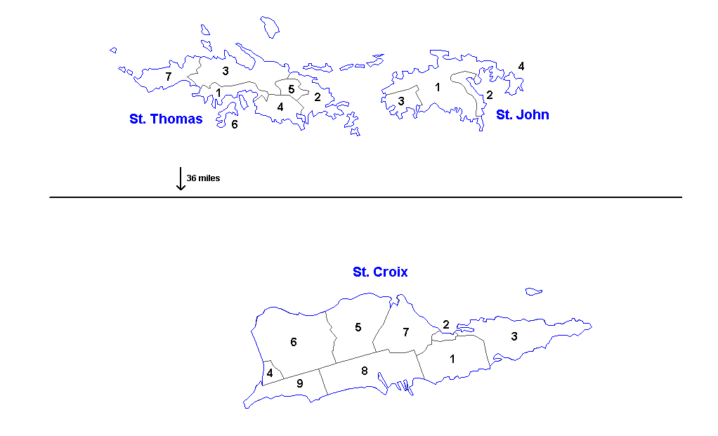
Administrative divisions of the U.S. Virgin Islands. Created by Rarelibra 16:11, 31 March 2006 (UTC) for public domain use. Created using MapInfo Professional v7.5 and vairous mapping resources.
| Districts | Saint Thomas | Saint John | Saint Croix |
|---|---|---|---|
| Sub-districts |
|
|
|
Lisensiering:
| Eg, opphavsrettshaldaren til dette verket, frigjev dette verket til ålmenta. Dette gjeld over heile verda. I somme landa er dette kan henda ikkje rettsleg mogeleg. I det fall: Eg gjev kven som helst rettane til å nytta dette verket for kva som helst føremål og utan vilkår, minder vilkår er kravde etter lova. |
Filhistorikk
Klikk på dato/klokkeslett for å sjå fila slik ho var på det tidspunktet.
| Dato/klokkeslett | Miniatyrbilete | Oppløysing | Brukar | Kommentar | |
|---|---|---|---|---|---|
| gjeldande | 19. mars 2014 kl. 15:57 | | 1 022 × 621 (33 KB) | Ahnoneemoos | removing border |
| 19. mars 2014 kl. 15:55 |  | 1 022 × 621 (33 KB) | Ahnoneemoos | removing border | |
| 27. november 2006 kl. 22:31 |  | 1 025 × 624 (15 KB) | Electionworld | {{ew|en|Rarelibra}} == Summary == Administrative divisions (districts and sub-districts) of the U.S. Virgin Islands. Created by Rarelibra 16:11, 31 March 2006 (UTC) for public domain use. Created using MapInfo Professional v7.5 and |
Filbruk
Den følgjande sida bruker denne fila:
Global filbruk
Desse andre wikiane nyttar fila:
- Bruk på ast.wikipedia.org
- Bruk på en.wikipedia.org
- Bruk på eu.wikipedia.org
- Bruk på gl.wikipedia.org
- Bruk på li.wikipedia.org
- Bruk på mk.wikipedia.org
- Bruk på ml.wikipedia.org
- Bruk på no.wikipedia.org
- Bruk på os.wikipedia.org
- Bruk på sr.wikipedia.org
- Bruk på ta.wikipedia.org
- Bruk på uk.wikipedia.org
- Bruk på vi.wikipedia.org
- Bruk på www.wikidata.org