
Fil:East Francia 843.svg

Storleik på denne PNG-førehandsvisinga av denne SVG-fila: 500 × 380 pikslar. Andre oppløysingar: 316 × 240 pikslar | 632 × 480 pikslar | 1 011 × 768 pikslar | 1 280 × 973 pikslar | 2 560 × 1 946 pikslar.
Opphavleg fil (SVG-fil, standardoppløysing: 500 × 380 pikslar, filstorleik: 933 KB)
Følgjande er henta frå filomtalen åt denne fila på Wikimedia Commons:
Skildring
Vektorgrafikken vart laga med Inkscape .


.svg)
.svg)
.svg)
.svg)
.svg)


.svg)
.svg)
.svg)


.png)
.png)


.svg)


.svg)

.svg)


.svg)
.svg)
.svg)
.svg)


.svg)
.png)


.svg)


.svg)
.svg)


.svg)


.svg)


.svg)
.svg)
.svg)
.svg)
.svg)
.svg)
.svg)
_cropped.svg)
.svg)
.svg)
.svg)
.svg)
.svg)
.svg)
.svg)
.svg)
.svg)
.svg)
.svg)
.svg)
.svg)
.svg)
.svg)
.svg)
.svg)
.svg)
.svg)
.svg)
.svg)
.svg)
.svg)
.svg)
.svg)
.svg)
.svg)
.svg)
.svg)
.svg)
.svg)
.svg)
.svg)
.svg)
.svg)
.svg)
.svg)
.svg)
.svg)
.svg)
.svg)
.svg)
.svg)
.svg)
.svg)
Lisensiering:
Denne fila er lisensiert under lisensen Creative Commons Namngjeving-DelPåSameVilkåra 4.0 internasjonal.
- Du står fritt til å:
- til å dela – til å kopiera, distibuera og overføra arbeidet
- til å blanda – til å endra verket
- På desse vilkåra:
- namngjeving – Du lyt godskriva verket på den måten som opphavpersonen eller lisensgjevaren har oppgjeve (men ikkje på ein slik måte at det kan verka som om dei går god for deg eller måten du nyttar verket på).
- del på same vilkåra – Om du remiksar, omarbeider, eller på annan måte byggjer på dette verket, kan du berre distribuera resultatet under den same eller ein samsvarande lisens som denne.
Filhistorikk
Klikk på dato/klokkeslett for å sjå fila slik ho var på det tidspunktet.
| Dato/klokkeslett | Miniatyrbilete | Oppløysing | Brukar | Kommentar | |
|---|---|---|---|---|---|
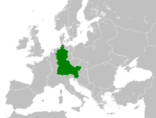
| gjeldande | 6. august 2021 kl. 12:06 | | 500 × 380 (933 KB) | E-960 | Vassal states (aka Slavic tribes) did not make up the territory of East Francia, also in most cases it only represented an alliance with East Francia rather than subjugation. |
| 26. mai 2016 kl. 04:25 |  | 500 × 380 (932 KB) | Alphathon | == {{int:filedesc}} == {{Inkscape}} {{Information |Description={{en|A map of East Francia within Europe circa 843 CE, following the treaty of Verdun.}} |Source= {{Derived from|Blank_map_of_Europe.svg|display=50}} '''Data sour... |
Filbruk
Det finst ikkje noka side som bruker denne fila.
Global filbruk
Desse andre wikiane nyttar fila:
- Bruk på azb.wikipedia.org
- Bruk på bg.wikipedia.org
- Bruk på ceb.wikipedia.org
- Bruk på cs.wikipedia.org
- Bruk på da.wikipedia.org
- Bruk på el.wikipedia.org
- Bruk på en.wikipedia.org
- Bruk på es.wikipedia.org
- Bruk på et.wikipedia.org
- Bruk på fa.wikipedia.org
- Bruk på fi.wikipedia.org
- Bruk på fr.wikipedia.org
- Bruk på fy.wikipedia.org
- Bruk på he.wikipedia.org
- Bruk på hr.wikipedia.org
- Bruk på hy.wikipedia.org
- Bruk på id.wikipedia.org
- Bruk på it.wikipedia.org
- Bruk på ja.wikipedia.org
- Bruk på ko.wikipedia.org
- Bruk på ku.wikipedia.org
- Bruk på la.wikipedia.org
- Bruk på lv.wikipedia.org
- Bruk på mk.wikipedia.org
- Bruk på pl.wikipedia.org
- Bruk på pt.wikipedia.org
- Bruk på ru.wikipedia.org
- Bruk på sl.wikipedia.org
- Bruk på sr.wikipedia.org
- Bruk på th.wikipedia.org
- Bruk på tr.wikipedia.org
- Bruk på uk.wikipedia.org
- Bruk på vi.wikipedia.org
Sjå meir global bruk av denne fila.