
Fil:Exeter-20may44.jpg
Høgare oppløysing er ikkje tilgjengeleg.
Exeter-20may44.jpg (600 × 555 pikslar, filstorleik: 79 KB, MIME-type: image/jpeg)
Følgjande er henta frå filomtalen åt denne fila på Wikimedia Commons:
Skildring
| Skildring |
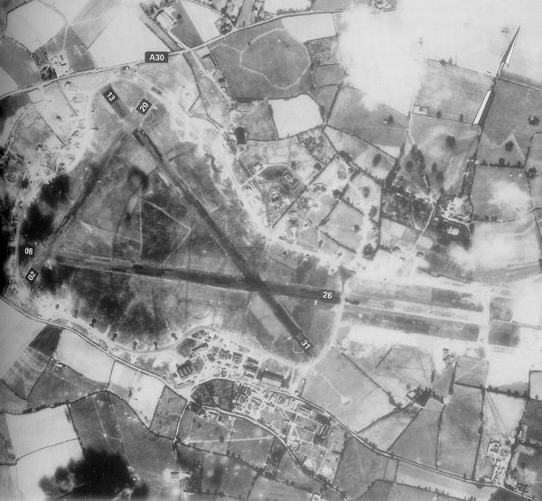
English: Exeter Airfield, England |
||||||
| Dato | |||||||
| Kjelde | Freeman, Roger A., Airfields Of The Ninth, Then And Now, 1993 (where the annotations are from) | ||||||
| Opphavsperson | Royal Ordinance Survey. | ||||||
| Løyve (Gjenbruk av denne fila) |
|

Opphavleg opplastingslogg
The original description page was here. All following user names refer to en.wikipedia.
- 2007-05-15 23:39 Bwmoll3 600×555×8 (81388 bytes) Exeter Airfield, England, 20 May 1944 Source: Royal Ordinance Survey. Crown Copyright expired 50 years after photograph taken in 1994. Annotations on photo from Freeman, Roger A., Airfields Of The Ninth, Then And Now, 1993
Filhistorikk
Klikk på dato/klokkeslett for å sjå fila slik ho var på det tidspunktet.
| Dato/klokkeslett | Miniatyrbilete | Oppløysing | Brukar | Kommentar | |
|---|---|---|---|---|---|
| gjeldande | 21. mai 2008 kl. 12:29 | | 600 × 555 (79 KB) | Aps1 | {{Information |Description={{en|Exeter Airfield, England, 20 May 1944 Source: Royal Ordinance Survey. Crown Copyright expired 50 years after photograph taken in 1994. Annotations on photo from Freeman, Roger A., Airfields Of The Ninth, Then And Now, 1993 |
Filbruk
Det finst ikkje noka side som bruker denne fila.
Global filbruk
Desse andre wikiane nyttar fila:
- Bruk på bg.wikipedia.org
- Bruk på ca.wikipedia.org
- Bruk på en.wikipedia.org
- Bruk på ru.wikipedia.org
- Bruk på si.wikipedia.org
- Bruk på uk.wikipedia.org
- Bruk på vi.wikipedia.org