
Fil:Map Bolivia territorial loss-en.svg

Storleik på denne PNG-førehandsvisinga av denne SVG-fila: 375 × 355 pikslar. Andre oppløysingar: 254 × 240 pikslar | 507 × 480 pikslar | 811 × 768 pikslar | 1 082 × 1 024 pikslar | 2 163 × 2 048 pikslar.
Opphavleg fil (SVG-fil, standardoppløysing: 375 × 355 pikslar, filstorleik: 78 KB)
Følgjande er henta frå filomtalen åt denne fila på Wikimedia Commons:
| Skildring |
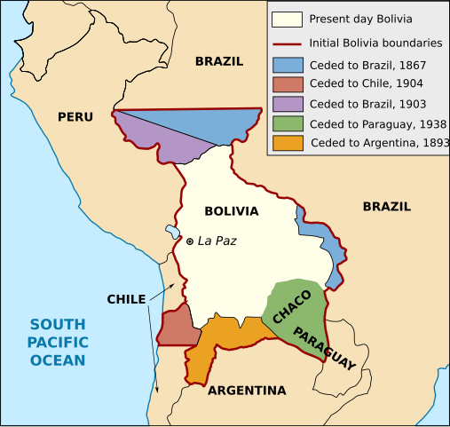
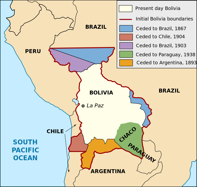
English: Territorial loss map of Bolivia |
| Dato | (UTC) |
| Kjelde | |
| Opphavsperson |
|
| Andre versjonar |
[]
Derivative works of this file: |


This work is in the public domain in the United States because it is a work prepared by an officer or employee of the United States Government as part of that person’s official duties under the terms of Title 17, Chapter 1, Section 105 of the US Code.
Note: This only applies to original works of the Federal Government and not to the work of any individual U.S. state, territory, commonwealth, county, municipality, or any other subdivision. This template also does not apply to postage stamp designs published by the United States Postal Service since 1978. (See § 313.6(C)(1) of Compendium of U.S. Copyright Office Practices). It also does not apply to certain US coins; see The US Mint Terms of Use.
|
 | |
| Denne fila er fastsett å vera fri for kjende avgrensingar under opphavsrettlovgjeving, medrekna alle relaterte og nærliggjande rettar. | ||
Filhistorikk
Klikk på dato/klokkeslett for å sjå fila slik ho var på det tidspunktet.
| Dato/klokkeslett | Miniatyrbilete | Oppløysing | Brukar | Kommentar | |
|---|---|---|---|---|---|
| gjeldande | 1. januar 2020 kl. 18:19 | | 375 × 355 (78 KB) | Janitoalevic | Added territory ceded to Argentina |
| 12. desember 2013 kl. 20:48 |  | 375 × 355 (68 KB) | Pethrus | Fixed ocean name | |
| 4. mai 2010 kl. 18:07 |  | 375 × 355 (68 KB) | Naturals | The territory of Paraguay was reversed with the territory of Brazil | |
| 3. mai 2010 kl. 21:06 |  | 375 × 355 (69 KB) | Pethrus | Paraguay border fixed | |
| 3. mai 2010 kl. 21:02 |  | 375 × 355 (69 KB) | Pethrus | Fixed bugs | |
| 3. mai 2010 kl. 20:56 |  | 375 × 355 (79 KB) | Pethrus | Inkscape bugs fixed | |
| 3. mai 2010 kl. 20:53 |  | 375 × 355 (81 KB) | Pethrus | {{Information |Description={{en|Territorial loss map of Bolivia}} |Source=*File:Bolivia_territorial_loss_map_LOC.jpg |Date=2010-05-03 18:51 (UTC) |Author=*File:Bolivia_territorial_loss_map_LOC.jpg: Library of Congress Country Study on Bolivia |
Filbruk
Det finst ikkje noka side som bruker denne fila.
Global filbruk
Desse andre wikiane nyttar fila:
- Bruk på az.wikipedia.org
- Bruk på ca.wikipedia.org
- Bruk på cs.wikipedia.org
- Bruk på da.wikipedia.org
- Bruk på de.wikipedia.org
- Bruk på en.wikipedia.org
- Bruk på eu.wikipedia.org
- Bruk på fi.wikipedia.org
- Bruk på fr.wikipedia.org
- Bruk på hi.wikipedia.org
- Bruk på hi.wiktionary.org
- Bruk på id.wikipedia.org
- Bruk på it.wikipedia.org
- Bruk på ja.wikipedia.org
- Bruk på ka.wikipedia.org
- Bruk på ko.wikipedia.org
- Bruk på lt.wikipedia.org
- Bruk på nl.wikipedia.org
- Bruk på pl.wikipedia.org
- Bruk på pt.wikipedia.org
- Bruk på sat.wikipedia.org
- Bruk på sd.wikipedia.org
- Bruk på sk.wikipedia.org
- Bruk på te.wikipedia.org
- Bruk på zh.wikipedia.org