
Fil:South Africa 2011 dominant population group map.svg

Storleik på denne PNG-førehandsvisinga av denne SVG-fila: 684 × 599 pikslar. Andre oppløysingar: 274 × 240 pikslar | 548 × 480 pikslar | 876 × 768 pikslar | 1 168 × 1 024 pikslar | 2 337 × 2 048 pikslar | 809 × 709 pikslar.
Opphavleg fil (SVG-fil, standardoppløysing: 809 × 709 pikslar, filstorleik: 787 KB)
Følgjande er henta frå filomtalen åt denne fila på Wikimedia Commons:
Skildring
| Skildring |
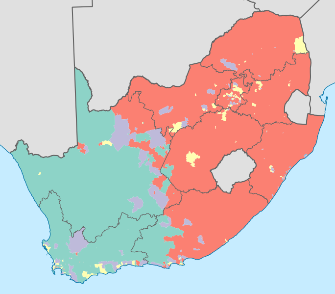
English: Map showing the dominant population groups in South Africa, according to Census 2011, at electoral ward level. A population group is considered dominant if it makes up more than 50% of the population in a ward, or if it makes up more than 33% and no other group makes up more than 25%.
Black African
Coloured
Indian or Asian
White
No group dominant
Projection is Albers Equal-Area Conic, with standard parallels at 25.5° S and 31.5° S, and origin at 28.5° S 25.5° E. |
| Dato | |
| Kjelde | Statistics South Africa's Census 2011 is the source of the basic population data. The map results from my own processing of the data. The map results from my own processing of the data. For ward boundaries see File:South Africa electoral wards 2011 blank.svg. |
| Opphavsperson | Htonl |
| Andre versjonar |
South Africa 2011 dominant population group map (hex cells).svg: .svg) |
Lisensiering:
The following license applies to the population data on which the map is based:

|
Denne filens rettighetsinnehaver, Stats SA, tillater alle å bruke filen til ethvert formål, forutsatt at rettighetsinnehaver blir korrekt kreditert. Redistribusjon, bearbeidelser, kommersiell bruk, og alle andre anvendelser er tillatt. |
Namngjeving:
"the user acknowledges Stats SA as the source of the basic data wherever they process, apply, utilise, publish or distribute the data, and also that they specify that the relevant application and analysis (where applicable) result from their own processing of the data" [1]
|
The following tag applies to the map itself:
| Eg, opphavsrettshaldaren til dette verket, frigjev dette verket til ålmenta. Dette gjeld over heile verda. I somme landa er dette kan henda ikkje rettsleg mogeleg. I det fall: Eg gjev kven som helst rettane til å nytta dette verket for kva som helst føremål og utan vilkår, minder vilkår er kravde etter lova. |
Filhistorikk
Klikk på dato/klokkeslett for å sjå fila slik ho var på det tidspunktet.
| Dato/klokkeslett | Miniatyrbilete | Oppløysing | Brukar | Kommentar | |
|---|---|---|---|---|---|
| gjeldande | 17. april 2013 kl. 02:13 | | 809 × 709 (787 KB) | Htonl | =={{int:filedesc}}== {{Information |Description={{en|1=Map showing the dominant population groups in South Africa, according to Census 2011, at electoral ward level. A population group is considered dominant if it makes up more than 50% of the populati... |
Filbruk
Det finst ikkje noka side som bruker denne fila.
Global filbruk
Desse andre wikiane nyttar fila:
- Bruk på af.wikipedia.org
- Bruk på cs.wikipedia.org
- Bruk på es.wikipedia.org
- Bruk på fr.wikipedia.org
- Bruk på he.wikipedia.org
- Bruk på it.wikipedia.org
- Bruk på ka.wikipedia.org
- Bruk på pt.wikipedia.org
- Bruk på ro.wikipedia.org
- Bruk på ru.wikipedia.org
- Bruk på sr.wikipedia.org
- Bruk på tg.wikipedia.org
- Bruk på uk.wikipedia.org
- Bruk på zh.wikipedia.org