
Fil:US Secession map 1861.svg

Storleik på denne PNG-førehandsvisinga av denne SVG-fila: 787 × 483 pikslar. Andre oppløysingar: 320 × 196 pikslar | 640 × 393 pikslar | 1 024 × 628 pikslar | 1 280 × 786 pikslar | 2 560 × 1 571 pikslar.
Opphavleg fil (SVG-fil, standardoppløysing: 787 × 483 pikslar, filstorleik: 111 KB)
Følgjande er henta frå filomtalen åt denne fila på Wikimedia Commons:
Skildring
{{Information
|Description=
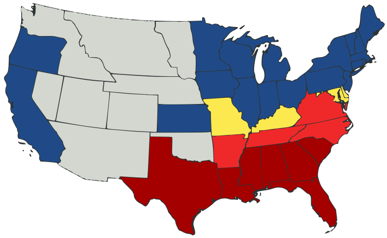
English: United States map of 1861, showing affiliation of states and territories regarding secession from the Union at the start of the American Civil War.
Legend:
States that seceded before April 15, 1861
States that seceded after April 15, 1861
States that permitted slavery, but did not secede
States of the Union where slavery was banned
U.S. territories, under Union Army control
|Date=2007-02-23
|Source=
Kjeldekoden til denne gyldig.
A trace, retouch, and recolour of Image:Secession Map of the United States, 1861.png by User:Tomf688.
|Author=[[User:ions= |Other fields= }}
Lisensiering:
Denne fila er lisensiert under lisensen Creative Commons Namngjeving-DelPåSameVilkåra 3.0 Unported
- Du står fritt til å:
- til å dela – til å kopiera, distibuera og overføra arbeidet
- til å blanda – til å endra verket
- På desse vilkåra:
- namngjeving – Du lyt godskriva verket på den måten som opphavpersonen eller lisensgjevaren har oppgjeve (men ikkje på ein slik måte at det kan verka som om dei går god for deg eller måten du nyttar verket på).
- del på same vilkåra – Om du remiksar, omarbeider, eller på annan måte byggjer på dette verket, kan du berre distribuera resultatet under den same eller ein samsvarande lisens som denne.
Filhistorikk
Klikk på dato/klokkeslett for å sjå fila slik ho var på det tidspunktet.
| Dato/klokkeslett | Miniatyrbilete | Oppløysing | Brukar | Kommentar | |
|---|---|---|---|---|---|
| gjeldande | 24. februar 2007 kl. 01:47 | | 787 × 483 (111 KB) | Tintazul | {{Tintazul |Description=United States map of 1861, show affiliation of states and territories regarding the Secession War (Civil War.) Legend: {{legend|#A40000|States that seceded before April 15, 1861}} {{legend|#EF2929|States that seceded after April 15 |
Filbruk
Det finst ikkje noka side som bruker denne fila.
Global filbruk
Desse andre wikiane nyttar fila:
- Bruk på ar.wikipedia.org
- Bruk på arz.wikipedia.org
- Bruk på be.wikipedia.org
- Bruk på bg.wikipedia.org
- Bruk på bs.wikipedia.org
- Bruk på cy.wikipedia.org
- Bruk på da.wikipedia.org
- Bruk på el.wikipedia.org
- Bruk på en.wikipedia.org
- American Civil War
- Irredentism
- Origins of the American Civil War
- User:Jimmuldrow/Sandbox
- Upland South
- User:ArmyAnt/Sandbox
- Presidency of Abraham Lincoln
- Presidency of James Buchanan
- James Buchanan
- Central Confederacy
- User:Themaster1112/sandbox
- User:2know4power/sandbox
- User:LukeRun82
- User:Orser67/Lincoln
- Bruk på es.wikipedia.org
- Bruk på eu.wikipedia.org
- Bruk på gd.wikipedia.org
- Bruk på he.wikipedia.org
- Bruk på hr.wikipedia.org
- Bruk på hy.wikipedia.org
- Bruk på it.wikipedia.org
- Bruk på ka.wikipedia.org
- Bruk på lij.wikipedia.org
- Bruk på lt.wikipedia.org
- Bruk på ml.wikipedia.org
- Bruk på ne.wikipedia.org
- Bruk på no.wikipedia.org
- Bruk på pl.wikipedia.org
- Bruk på pt.wikipedia.org
Sjå meir global bruk av denne fila.