
Fil:Xinjiang Internment Map, US-Aus Gov Assessment.jpg
Storleik på førehandsvising: 800 × 495 pikslar. Andre oppløysingar: 320 × 198 pikslar | 640 × 396 pikslar | 1 024 × 634 pikslar | 1 280 × 792 pikslar | 2 048 × 1 267 pikslar.
Opphavleg fil (2 048 × 1 267 pikslar, filstorleik: 150 KB, MIME-type: image/jpeg)
Følgjande er henta frå filomtalen åt denne fila på Wikimedia Commons:
Skildring
| Skildring |
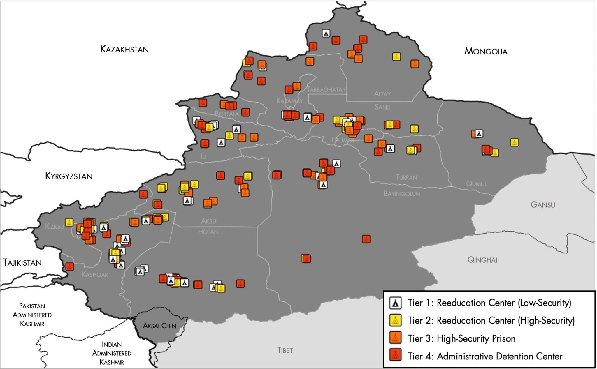
English: Map of the Xinjiang Internment Camps created by the RAND Corporation based on data collected by the US National Geospatial Intelligence Agency and the Australian Strategic Policy Institute. Open source here. |
||||||||
| Dato | |||||||||
| Kjelde | https://www.tearline.mil/public_page/xinjiang-nighttime-1/ | ||||||||
| Opphavsperson | National Geospatial Intelligence Agency, using data from the Australian Strategic Policy Institute, and administrative boundaries from GADM. | ||||||||
| Løyve (Gjenbruk av denne fila) |
|


Filhistorikk
Klikk på dato/klokkeslett for å sjå fila slik ho var på det tidspunktet.
| Dato/klokkeslett | Miniatyrbilete | Oppløysing | Brukar | Kommentar | |
|---|---|---|---|---|---|
| gjeldande | 2. mai 2021 kl. 07:05 | | 2 048 × 1 267 (150 KB) | Abovfold | Uploaded a work by {{w|National Geospatial Intelligence Agency}}, using data from the {{w|Australian Strategic Policy Institute}}, and administrative boundaries from {{w|GADM}}. from https://www.tearline.mil/public_page/xinjiang-nighttime-1/ with UploadWizard |
Filbruk
Det finst ikkje noka side som bruker denne fila.
Global filbruk
Desse andre wikiane nyttar fila:
- Bruk på ba.wikipedia.org
- Bruk på br.wikipedia.org
- Bruk på cs.wikipedia.org
- Bruk på de.wikipedia.org
- Bruk på el.wikipedia.org
- Bruk på en.wikipedia.org
- Bruk på es.wikipedia.org
- Bruk på fi.wikipedia.org
- Bruk på fr.wikipedia.org
- Bruk på ga.wikipedia.org
- Bruk på he.wikipedia.org
- Bruk på km.wikipedia.org
- Bruk på nl.wikipedia.org
- Bruk på or.wikipedia.org
- Bruk på pl.wikipedia.org
- Bruk på pt.wikipedia.org
- Bruk på ru.wikinews.org
- Bruk på sv.wikipedia.org
- Bruk på szl.wikipedia.org
- Bruk på tr.wikipedia.org
- Bruk på www.wikidata.org