
Fil:Arabian tectonic plate overview map.png
Høgare oppløysing er ikkje tilgjengeleg.
Arabian_tectonic_plate_overview_map.png (213 × 203 pikslar, filstorleik: 19 KB, MIME-type: image/png)
Følgjande er henta frå filomtalen åt denne fila på Wikimedia Commons:
Skildring
| Skildring |
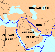
English: Overview map of the Arabian tectonic plate. |
| Dato | Ukjend dato, uploaded 2012-01-17 |
| Kjelde |
http://neic.usgs.gov/neis/gifs/iran_plates.gif Used in document: http://neic.usgs.gov/neis/eq_depot/2004/eq_040528/neic_jaan_ts.html
|
| Opphavsperson | U.S. Geological Survey |
Lisensiering:
This work is in the public domain in the United States because it is a work prepared by an officer or employee of the United States Government as part of that person’s official duties under the terms of Title 17, Chapter 1, Section 105 of the US Code.
Note: This only applies to original works of the Federal Government and not to the work of any individual U.S. state, territory, commonwealth, county, municipality, or any other subdivision. This template also does not apply to postage stamp designs published by the United States Postal Service since 1978. (See § 313.6(C)(1) of Compendium of U.S. Copyright Office Practices). It also does not apply to certain US coins; see The US Mint Terms of Use.
|
 | |
| Denne fila er fastsett å vera fri for kjende avgrensingar under opphavsrettlovgjeving, medrekna alle relaterte og nærliggjande rettar. | ||
Opphavleg opplastingslogg
| Dato/klokkeslett | Oppløysing | Brukar | Kommentar |
|---|---|---|---|
| 17. januar 2012, 13:29:04 | 213 × 203 (14751 bytes) | Rwendland (diskusjon · bidrag) |
Filhistorikk
Klikk på dato/klokkeslett for å sjå fila slik ho var på det tidspunktet.
| Dato/klokkeslett | Miniatyrbilete | Oppløysing | Brukar | Kommentar | |
|---|---|---|---|---|---|
| gjeldande | 17. august 2014 kl. 21:48 | | 213 × 203 (19 KB) | GifTagger | Bot: Converting file to superior PNG file. (Source: Arabian_tectonic_plate_overview_map.gif). This GIF was problematic due to transparency and non-greyscale color table. |
Filbruk
Den følgjande sida bruker denne fila:
Global filbruk
Desse andre wikiane nyttar fila:
- Bruk på azb.wikipedia.org
- Bruk på da.wikipedia.org
- Bruk på en.wikipedia.org
- Bruk på hi.wikipedia.org
- Bruk på id.wikipedia.org
- Bruk på it.wikipedia.org
- Bruk på pl.wikipedia.org
- Bruk på sl.wikipedia.org
- Bruk på zh.wikipedia.org