
Fil:C74193s5 Ant.Map Mount Melbourne.jpg

Storleik på førehandsvising: 644 × 600 pikslar. Andre oppløysingar: 258 × 240 pikslar | 515 × 480 pikslar | 824 × 768 pikslar | 1 099 × 1 024 pikslar | 2 198 × 2 048 pikslar | 3 493 × 3 254 pikslar.
Opphavleg fil (3 493 × 3 254 pikslar, filstorleik: 1,68 MB, MIME-type: image/jpeg)
Følgjande er henta frå filomtalen åt denne fila på Wikimedia Commons:
Skildring
| Skildring |
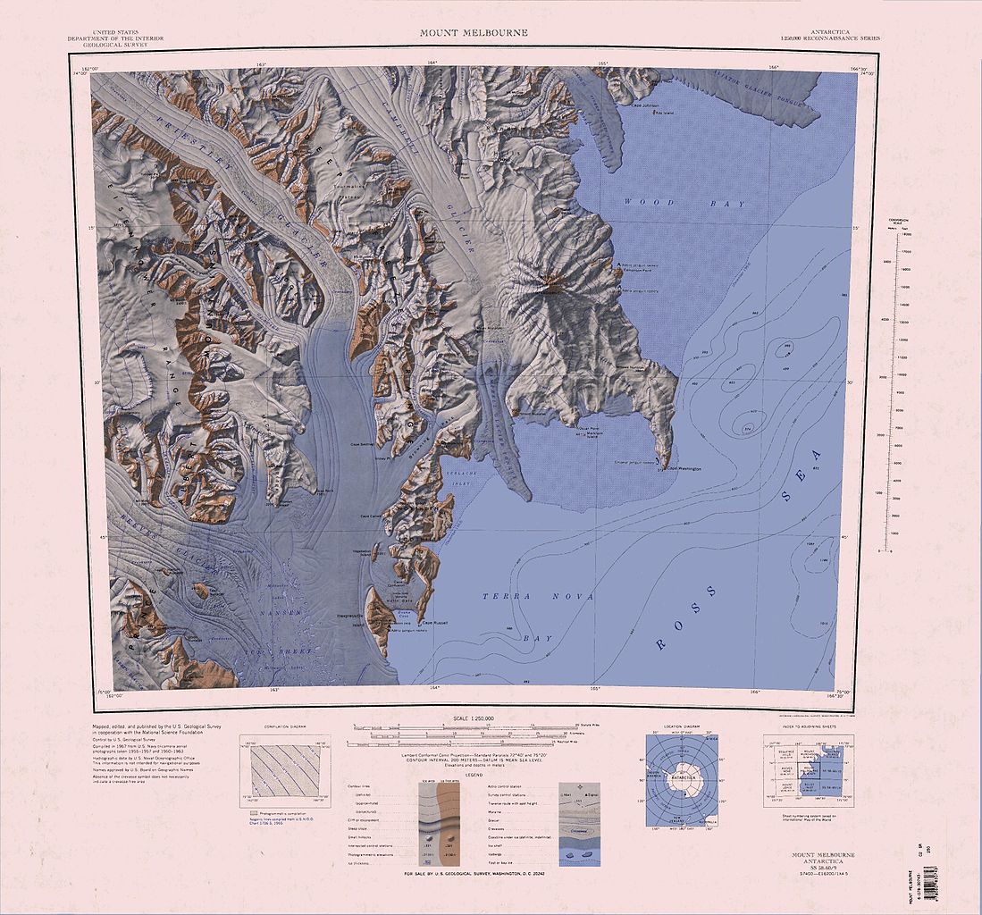
English: 1:250,000-scale topographic reconnaissance map of the Mount Melbourne area from 162°-166°30'E to 74°-75°S in Antarctica. Mapped, edited and published by the U.S. Geological Survey in cooperation with the National Science Foundation. |
|||
| Dato | ||||
| Kjelde | http://usarc.usgs.gov/drg_dload.shtml | |||
| Opphavsperson | United States Geological Survey | |||
| Løyve (Gjenbruk av denne fila) |
|
|||
| Andre versjonar | Derivative works of this file: Baker Rocks.jpg |
| Annotations | This image is annotated: View the annotations at Commons |
Filhistorikk
Klikk på dato/klokkeslett for å sjå fila slik ho var på det tidspunktet.
| Dato/klokkeslett | Miniatyrbilete | Oppløysing | Brukar | Kommentar | |
|---|---|---|---|---|---|
| gjeldande | 4. april 2005 kl. 08:51 | | 3 493 × 3 254 (1,68 MB) | Achim Raschka | Map of Antarctica by the United States Antarctic Ressource Center of the US Geological Society. {{PD-US}} Copyrights and Trademarks USGS-authored or produced data and information are in the public domain. While the content of most USGS web pages is in th |
Filbruk
Den følgjande sida bruker denne fila:
Global filbruk
Desse andre wikiane nyttar fila:
- Bruk på bg.wikipedia.org
- Bruk på ceb.wikipedia.org
- Bruk på de.wikipedia.org
- Mount Baxter
- Mount Nansen
- Terra Nova Bay
- Hansen-Nunatak
- Nansen-Eistafel
- Reeves-Gletscher
- Teall-Nunatak
- Prince Albert Mountains
- Kap Russell
- Eisenhower Range
- Priestley-Gletscher
- Deep Freeze Range
- Northern Foothills
- Browning-Pass
- Cape Canwe
- Vegetation Island
- Wood Bay
- Kap Washington
- Corner-Gletscher
- Mount Borgstrom
- Mount Meister
- Nash Ridge
- O’Kane-Gletscher
- Eskimo Point
- O’Kane Canyon
- Pinckard Table
- Wood Ridge (Antarktika)
- Random Hills
- Cape Confusion
- Polar-3-Halbinsel
- Gerlache Inlet
- Hells Gate (Antarktika)
- Mount Keinath
- Snowy Point
- Föhnhalbinsel
- Westantarktisches Riftsystem
- Bruk på en.wikipedia.org
Sjå meir global bruk av denne fila.