
Fil:John-Speed-The-Kingdome-of-China-1626-2544.jpg

Opphavleg fil (2 024 × 1 640 pikslar, filstorleik: 3,98 MB, MIME-type: image/jpeg)
Følgjande er henta frå filomtalen åt denne fila på Wikimedia Commons:
| Skildring |
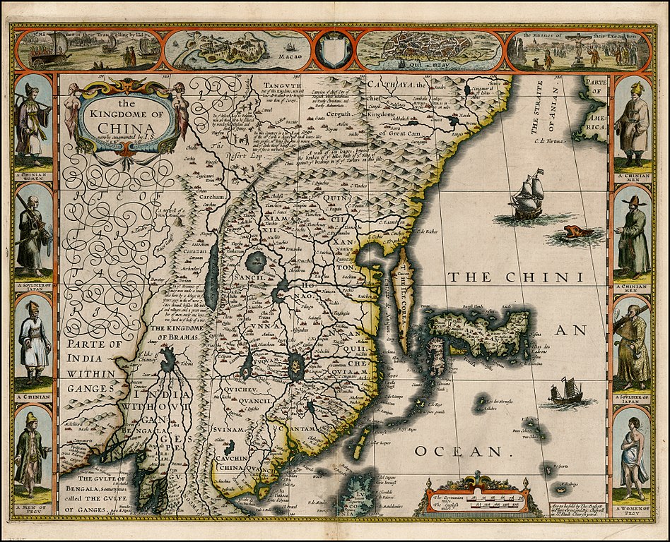
English: "The Kingdome of China", one of the first English-language maps of China. Note generally correct outline of the Ming China, with many provinces labeled (Cantam/Guangdong, Quancii/Guangxi, Chequiam/Zhejiang, Quicheu/Guizhou, Fuquam/en:Huguang/Huguang, Honao/Henan, Xanton/Shandong, Xiamxii and Sancii (Shanxi and Shaanxi?). "Xuntien alias Quinzay" more or less corresponds to Beijing (the name Shuntian Prefecture was indeed in use). However, north of China proper, John Speed had also placed "Cathaya, the Chief Kingdome of Great Cam", with the capital Cambalu (Khanbaliq - i.e., in fact, the same Beijing). This kind of duplication was common on the maps of the period, as geographers had not apparently yet fully identified Marco Polo's Cathay with the China then known to Europeans, and Cambalu with Beijing. |
|||||||||||||||||
| Dato | Originally published 1626, reprint 1627 | |||||||||||||||||
| Kjelde |
English: An antique map from the Special Collection "China in Maps" of the Hong Kong University of Science and Technology Library, reproduced by the HKUST Library in the book "China in European Maps", Hong Kong, 2003. ISBN 962-86403-9-9.
Русский: Старинная карта из специальной коллекции Библиотеки Гонконгского научно-технического университета. Опубликована этой библиотекой в книге "China in European Maps" (Китай на европейских картах), Гонконг, 2003. ISBN 962-86403-9-9, тиражом 1000 экз. См. также каталог выставки, Special Collection "China in Maps".
Plate 21 |
|||||||||||||||||
| Opphavsperson |
|
|||||||||||||||||
| Løyve (Gjenbruk av denne fila) |
Author died more than 70 years ago - public domain | |||||||||||||||||

|
Dette verket er falt i det fri i Noreg, og dei landa som har opphavsrettsleg vernetid på 70 år etter opphavsmannen sin død, eller kortare.
| |
| Denne fila er fastsett å vera fri for kjende avgrensingar under opphavsrettlovgjeving, medrekna alle relaterte og nærliggjande rettar. | |
Filhistorikk
Klikk på dato/klokkeslett for å sjå fila slik ho var på det tidspunktet.
| Dato/klokkeslett | Miniatyrbilete | Oppløysing | Brukar | Kommentar | |
|---|---|---|---|---|---|
| gjeldande | 28. januar 2010 kl. 14:38 | | 2 024 × 1 640 (3,98 MB) | Vmenkov | better scan of same map, from http://www.raremaps.com/gallery/detail/22839/the_Kingdome_of_China_newly_augmented_by_IS_1626/Speed.html |
| 22. mars 2009 kl. 02:35 |  | 2 560 × 1 920 (2,11 MB) | Vmenkov | {{Information |Description={{en|"The Kingdome of China", one of the first English-language maps of China. Note generally correct outline of the Ming China, with many provinces labeled (Cantam/Guangdong, Quancii/Guangxi, Chequiam/Zhejiang, Quicheu/Guizhou, |
Filbruk
Den følgjande sida bruker denne fila:
Global filbruk
Desse andre wikiane nyttar fila:
- Bruk på ar.wikipedia.org
- Bruk på arz.wikipedia.org
- Bruk på ast.wikipedia.org
- Bruk på bg.wikipedia.org
- Bruk på bn.wikipedia.org
- Bruk på ca.wikipedia.org
- Bruk på cv.wikipedia.org
- Bruk på de.wikivoyage.org
- Bruk på el.wikipedia.org
- Bruk på en.wikipedia.org
- Bruk på en.wikivoyage.org
- Bruk på es.wikipedia.org
- Bruk på eu.wikipedia.org
- Bruk på fa.wikipedia.org
- Bruk på fi.wikipedia.org
- Bruk på fr.wikipedia.org
- Bruk på he.wikipedia.org
- Bruk på hu.wikipedia.org
- Bruk på hy.wikipedia.org
- Bruk på id.wikipedia.org
- Bruk på it.wikipedia.org
- Bruk på kk.wikipedia.org
- Bruk på ko.wikipedia.org
- Bruk på la.wikipedia.org
- Bruk på nl.wikipedia.org
- Bruk på pl.wikipedia.org
- Bruk på pnb.wikipedia.org
- Bruk på pt.wikipedia.org
- Bruk på ru.wikipedia.org
Sjå meir global bruk av denne fila.