Fil:John Speed Wales.jpg

Sideinnhaldet er ikkje støtta på andre språk.
Frå Wikipedia – det frie oppslagsverket

Opphavleg fil(5 010 × 3 838 pikslar, filstorleik: 8,25 MB, MIME-type: image/jpeg)

Denne fila er frå Wikimedia Commons og kan verta nytta av andre prosjekt. Skildringa frå filskildringssida der er vist nedanfor.


Følgjande er henta frå filomtalen åt denne fila på Wikimedia Commons:


Skildring

John Speed: John Speed's map of Wales  wikidata:Q22912348 reasonator:Q22912348
Kunstnar
John Speed  (–1629)  wikidata:Q1245028 s:en:Author:John Speed
 
John Speed
Skildring britisk kartograf og historikar
Fødsels-/dødsdato ca. 1552
date QS:P,+1552-00-00T00:00:00Z/9,P1480,Q5727902
29. juli 1629
Føde-/dødssted Farndon London
Autoritetsdata
artist QS:P170,Q1245028
image of artwork listed in title parameter on this page
Tittel
John Speed's map of Wales, 1610
Utgiver
Objekttype kart / trykk Redigere på wikidata
Skildring
Français : Carte du Pays de Galles, par John Speed, 1610.
Cymraeg: Map o Cymru gan John Speed, 1610
English: Map of Wales by John Speed, 1610.
Shows Welsh counties and parts of adjoining English counties, including much of Herefordshire and Shropshire. Identifies towns, larger villages parish churches, rivers and diagramatic representation of higher hills and mountains. Compass rose in Irish Sea bearing the Arms of the Princes of Wales at its centre, the sea shaded to resemble watered silk in the style of Hondius.
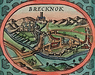
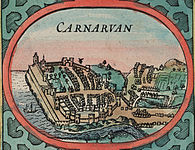
The sides of the maps are flanked by twelve views of the County Towns of Wales with smaller insets of the four Cathedral Cities of Bangor, St Asaph, Llandaff and St. David's set into each of the map's corners.
Text verso printed upside down on pages 99 and 100 of "The generall description, and severall divisions of the Principality of Wales." Sign Ggg....sold by John Sudbury and George Humble in Popes head allye - cum privilegio. 1610.
Dato 1610
date QS:P571,+1610-00-00T00:00:00Z/9
Dimensjonar 360 × 330 mm
institution QS:P195,Q666063
Utgivelsessted London Redigere på wikidata
Merknader Scale (1:576.000)
Autoritetsdata
Kjelde/Fotograf
This image is available from the National Library of Wales
You can view this image in its original context on the NLW Catalogue
Løyve
(Gjenbruk av denne fila)
Public domain

Dette verket er falt i det fri i Noreg, og dei landa som har opphavsrettsleg vernetid på 100 år etter opphavsmannen sin død, eller kortare.


This work is in the public domain in the United States because it was published (or registered with the U.S. Copyright Office) before January 1, 1929.

Andre versjonar Cropped Inserts of principal towns:

VI seal

This image has been assessed under the valued image criteria and is considered the most valued image on Commons within the scope: Map of Wales by John Speed. You can see its nomination here.

Bilettekstar

Skriv inn ei line med tekst som skildrar fila

Element som er med i denne fila

motiv

Filhistorikk

Klikk på dato/klokkeslett for å sjå fila slik ho var på det tidspunktet.

Dato/klokkeslettMiniatyrbileteOppløysingBrukarKommentar
gjeldande21. oktober 2015 kl. 15:01Miniatyrbilete av versjonen frå 21. oktober 2015 kl. 15:015 010 × 3 838 (8,25 MB)Jason.nlwUser created page with UploadWizard

Den følgjande sida bruker denne fila:

Global filbruk

Desse andre wikiane nyttar fila:

Utvida informasjon