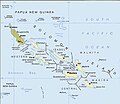
Fil:Political map of the Solomon Islands archipelago in 1989.jpg

Storleik på førehandsvising: 690 × 600 pikslar. Andre oppløysingar: 276 × 240 pikslar | 552 × 480 pikslar | 748 × 650 pikslar.
Opphavleg fil (748 × 650 pikslar, filstorleik: 72 KB, MIME-type: image/jpeg)

Følgjande er henta frå filomtalen åt denne fila på Wikimedia Commons:
Filhistorikk
Klikk på dato/klokkeslett for å sjå fila slik ho var på det tidspunktet.
| Dato/klokkeslett | Miniatyrbilete | Oppløysing | Brukar | Kommentar | |
|---|---|---|---|---|---|
| gjeldande | 12. april 2016 kl. 04:06 |  | 748 × 650 (72 KB) | Nimbosa | Reverted to version as of 02:02, 12 April 2016 (UTC) |
| 12. april 2016 kl. 04:05 |  | 748 × 650 (72 KB) | Nimbosa | restored to original color as on print, corrected color map | |
| 12. april 2016 kl. 04:02 |  | 748 × 650 (72 KB) | Nimbosa | restored to original color as on print, corrected color map | |
| 1. mars 2007 kl. 23:09 |  | 748 × 650 (72 KB) | Pibwl |
Filbruk
Det finst ikkje noka side som bruker denne fila.
Global filbruk
Desse andre wikiane nyttar fila:
- Bruk på als.wikipedia.org
- Bruk på ami.wikipedia.org
- Bruk på ast.wikipedia.org
- Bruk på bg.wikipedia.org
- Bruk på bn.wikipedia.org
- Bruk på ca.wikipedia.org
- Bruk på ceb.wikipedia.org
- Bruk på cs.wikipedia.org
- Bruk på da.wikipedia.org
- Bruk på el.wikipedia.org
- Bruk på en.wikipedia.org
- New Georgia Islands
- Solomon Islands rain forests
- New Georgia Sound
- New Georgia
- North Solomon Islands
- Solomon Archipelago
- List of resident commissioners and governors of the Solomon Islands
- Solomon Islands (archipelago)
- Bougainville Strait
- Coral reefs of the Solomon Islands
- Draft:Arthur William Mahaffy
- Bruk på en.wiktionary.org
- Bruk på es.wikipedia.org
- Bruk på fa.wikipedia.org
- Bruk på fi.wikipedia.org
- Bruk på fr.wikipedia.org
- Bruk på gl.wikipedia.org
- Bruk på hu.wikipedia.org
- Bruk på hy.wikipedia.org
- Bruk på hyw.wikipedia.org
- Bruk på id.wikipedia.org
- Bruk på it.wikipedia.org
- Bruk på ja.wikipedia.org
- Bruk på ka.wikipedia.org
- Bruk på kk.wikipedia.org
Sjå meir global bruk av denne fila.


