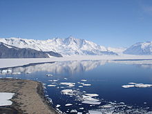
Mount Herschel
| Mount Herschel | |||
| fjell | |||
Mount Herschel frå Cape Hallett
| |||
| Land | |||
|---|---|---|---|
| Fjellkjede | Admiralty Mountains | ||
| Topp | Victoria Land | ||
| - høgd | 3 335 moh. [1] | ||
| - koordinatar | 72°12′S 169°31′E / 72.200°S 169.517°E | ||
| Førstestiging | Sir Edmund Hillary og party[2] | ||
| Administrert under | Antarktistraktaten | ||
 Mount Herschel 72°12′00″S 169°31′00″E / 72.2°S 169.51666666667°E | |||
| Wikimedia Commons: Mount Herschel | |||
Mount Herschel er eit kjenneleg fjell som ligg 2,6 km nordaust for Mount Peacock og oppom enden av Ironsidebreen frå sør, i Admiralty Mountains i Victoria Land i Antarktis.[1]
Fjellet vart oppdaga i 1841 av Sir James Clark Ross, som namngav dette fjellet etter Sir John F.W. Herschel, ein kjend engelsk astronom.[1]
Kjelder[endre | endre wikiteksten]
- Denne artikkelen bygger på «Mount Herschel» frå Wikipedia på engelsk, den 26. mars 2013.
- Wikipedia på engelsk oppgav desse kjeldene:
- ↑ 1,0 1,1 1,2 «Mount Herschel». Geographic Names Information System. United States Geological Survey, United States Department of the Interior.
- ↑ Sir Edmund Percival Hillary


