
Fil:Camargue map.png
Høgare oppløysing er ikkje tilgjengeleg.
Camargue_map.png (718 × 396 pikslar, filstorleik: 42 KB, MIME-type: image/png)
Følgjande er henta frå filomtalen åt denne fila på Wikimedia Commons:
Skildring
| Skildring | ||||
| Dato | ||||
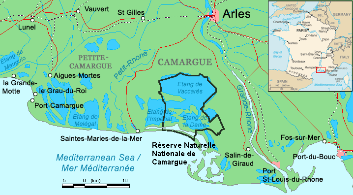
| Kjelde | Combination of CIA World Factbook map (Image:Fr-map.png) and Demis Map Server (http://www2.demis.nl/mapserver/mapper.asp) data with additional annotations and modifications by self. | |||
| Opphavsperson | ChrisO | |||
| Andre versjonar |
File:Camargue, Petite Caramgue et Parc naturel reg.png (relaunched and actualized)
|

Filhistorikk
Klikk på dato/klokkeslett for å sjå fila slik ho var på det tidspunktet.
| Dato/klokkeslett | Miniatyrbilete | Oppløysing | Brukar | Kommentar | |
|---|---|---|---|---|---|
| gjeldande | 29. april 2016 kl. 23:34 | | 718 × 396 (42 KB) | Rsuessbr | Writing of Petite-Camargue corrected |
| 10. august 2015 kl. 19:15 |  | 718 × 396 (42 KB) | Rsuessrb | Added: limits of the natural park (according to a map published by snpn (Société Nationale de Protection de la Nature), 2015 | |
| 20. mars 2012 kl. 03:23 |  | 718 × 396 (38 KB) | Ras67 | cropped | |
| 16. august 2006 kl. 22:52 |  | 720 × 398 (41 KB) | ChrisO | Map of the Camargue region, southern France By ~~~, derived from open source mapping | |
| 16. august 2006 kl. 22:46 |  | 720 × 398 (40 KB) | ChrisO | Map of the Camargue region, southern France By ~~~, derived from open source mapping |
Filbruk
Den følgjande sida bruker denne fila:
Global filbruk
Desse andre wikiane nyttar fila:
- Bruk på af.wikipedia.org
- Bruk på ar.wikipedia.org
- Bruk på az.wikipedia.org
- Bruk på br.wikipedia.org
- Bruk på co.wikipedia.org
- Bruk på cs.wikipedia.org
- Bruk på cy.wikipedia.org
- Bruk på de.wikipedia.org
- Bruk på en.wikipedia.org
- Bruk på eo.wikipedia.org
- Bruk på es.wikipedia.org
- Bruk på fi.wikipedia.org
- Bruk på fr.wikipedia.org
- Bruk på gl.wikipedia.org
- Bruk på hu.wikipedia.org
- Bruk på id.wikipedia.org
- Bruk på it.wikipedia.org
- Bruk på ja.wikipedia.org
- Bruk på ko.wikipedia.org
- Bruk på lt.wikipedia.org
- Bruk på mt.wikipedia.org
- Bruk på nl.wikipedia.org
- Bruk på no.wikipedia.org
- Bruk på oc.wikipedia.org
Sjå meir global bruk av denne fila.