
Fil:Deception Island Map.svg

Storleik på denne PNG-førehandsvisinga av denne SVG-fila: 644 × 599 pikslar. Andre oppløysingar: 258 × 240 pikslar | 516 × 480 pikslar | 825 × 768 pikslar | 1 101 × 1 024 pikslar | 2 201 × 2 048 pikslar | 820 × 763 pikslar.
Opphavleg fil (SVG-fil, standardoppløysing: 820 × 763 pikslar, filstorleik: 461 KB)
Følgjande er henta frå filomtalen åt denne fila på Wikimedia Commons:
| Skildring |
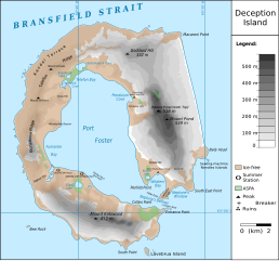
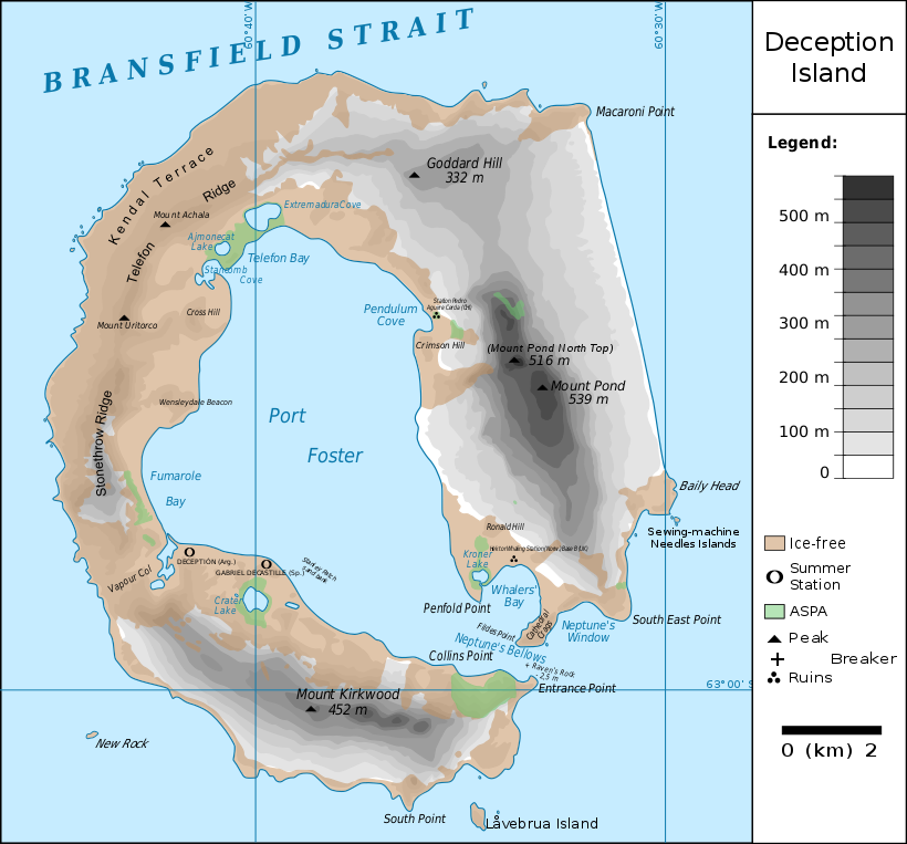
Français : carte de l'île de la Déception avec les toponymes + la position des stations ainsi que des zones protégées
English: map of Deception Island with the topography and the location of the stations and protected zones |
| Dato | (UTC) |
| Kjelde | |
| Opphavsperson |
|
| This is a retouched picture, which means that it has been digitally altered from its original version. The original can be viewed here: Ile de la Deception.svg:
|
Eg, opphavsrettshaldaren til verket, publiserer det hermed under desse lisensane:
Fila er lisensiert under Creative Commons Namngjeving 3.0 Unported.
- Du står fritt til å:
- til å dela – til å kopiera, distibuera og overføra arbeidet
- til å blanda – til å endra verket
- På desse vilkåra:
- namngjeving – Du lyt godskriva verket på den måten som opphavpersonen eller lisensgjevaren har oppgjeve (men ikkje på ein slik måte at det kan verka som om dei går god for deg eller måten du nyttar verket på).

|
Det er tillate å kopiera, distribuera og/eller modifisera dette dokumentet under retningslinene som er skildra i GNU fri dokumentasjonslisens, versjon 1.2 eller seinare utgåve utgjeven av Free Software Foundation; med alle seksjonane, utan nokon framsidetekstar og baksidetekstar. Ein kopi av lisensen er inkludert i avsnittet GNU Free Documentation License. |
Du kan velje den lisensen du sjølv tykkjer er best.
Opphavleg opplastingslogg
This image is a derivative work of the following images:
- File:Ile_de_la_Deception.svg licensed with Cc-by-3.0, GFDL
- 2010-06-19T09:08:35Z Treehill 820x763 (464885 Bytes) carrés noirs (tentative)
- 2010-06-18T17:48:51Z Treehill 820x763 (465569 Bytes) deux dernières légendes alignées
- 2010-06-18T17:30:49Z Treehill 820x763 (465601 Bytes) nom de la baie à gauche
- 2010-06-18T17:20:48Z Treehill 820x763 (465594 Bytes) déplacement de certains textes + 1ère tentative de suppression des carrés
- 2010-06-18T14:02:39Z Treehill 820x763 (465599 Bytes) {{Information |Description={{fr|1=carte de l'île de la Déception avec les toponymes + la position des stations ainsi que des zones protégées}} |Source={{own}} |Author=[[User:Treehill|Treehill]] |Date= |Permission= |other_
Uploaded with derivativeFX
Filhistorikk
Klikk på dato/klokkeslett for å sjå fila slik ho var på det tidspunktet.
| Dato/klokkeslett | Miniatyrbilete | Oppløysing | Brukar | Kommentar | |
|---|---|---|---|---|---|
| gjeldande | 13. mai 2018 kl. 23:59 | | 820 × 763 (461 KB) | Hogweard | Rm duplicate |
| 25. mars 2018 kl. 14:45 |  | 820 × 763 (462 KB) | Hogweard | Corrected height of Pond North Top; Fumarole Bay and additional names. | |
| 18. september 2016 kl. 18:35 |  | 820 × 763 (459 KB) | Maproom | 1.) Word "Station" no longer extends off edge of image 2.) "Peak" is spelled without a ffinal "t" 3.) "Breaker" is written in the right place instead of overwritten on "peak" | |
| 10. oktober 2010 kl. 13:01 |  | 820 × 763 (459 KB) | Fitzgabbro | Fixed curved writing | |
| 10. oktober 2010 kl. 00:11 |  | 820 × 763 (353 KB) | Fitzgabbro | {{Information |Description={{fr|1=carte de l'île de la Déception avec les toponymes + la position des stations ainsi que des zones protégées}} {{en|1=map of Deception Island with the topography and the location of the stations and protected zones}} |S |
Filbruk
Den følgjande sida bruker denne fila:
Global filbruk
Desse andre wikiane nyttar fila:
- Bruk på ceb.wikipedia.org
- Bruk på cs.wikipedia.org
- Bruk på de.wikipedia.org
- Deception Island
- Mount Achala
- Telefon Ridge
- Telefon Bay
- Port Foster
- Ajmonecatsee
- Stancomb Cove
- Laguna Hill
- Fildes Point
- Neptunes Bellows
- Whalers Bay
- Penfold Point
- Collins Point
- Crater Lake (Deception Island)
- Mount Kirkwood
- Entrance Point
- Crimson Hill
- Kendall Terrace
- Kroner Lake
- Låvebrua Island
- South Point (Deception Island)
- New Rock (Südliche Shetlandinseln)
- Mount Pond
- Primero de Mayo Bay
- Ravn Rock
- Ronald Hill
- South East Point
- Stonethrow Ridge
- Vapour Col
- Bruk på en.wikipedia.org
- Bruk på eu.wikipedia.org
- Bruk på it.wikipedia.org
- Bruk på ja.wikipedia.org
- Bruk på lld.wikipedia.org
- Bruk på nds.wikipedia.org
- Bruk på nl.wikipedia.org
- Bruk på pl.wikipedia.org
- Bruk på ru.wikipedia.org
Sjå meir global bruk av denne fila.