
Fil:Karte Deutsch-Dänischer Krieg Militärereignisse.png

Storleik på førehandsvising: 501 × 600 pikslar. Andre oppløysingar: 200 × 240 pikslar | 401 × 480 pikslar | 641 × 768 pikslar | 855 × 1 024 pikslar | 1 861 × 2 228 pikslar.
Opphavleg fil (1 861 × 2 228 pikslar, filstorleik: 708 KB, MIME-type: image/png)
Følgjande er henta frå filomtalen åt denne fila på Wikimedia Commons:
| Skildring |
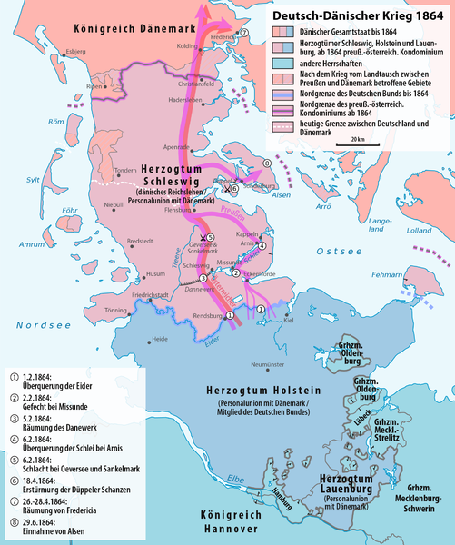
Deutsch: Karte der militärischen Ereignisse während und der Grenzänderungen durch den Deutsch-Dänischen Krieg
English: Map of the military events and of the boundary changes during the Second Schleswig War. Text in German. |
| Dato | see file history |
| Kjelde |
Eige arbeid, using |
| Opphavsperson | Maximilian Dörrbecker (Chumwa) |
| Løyve (Gjenbruk av denne fila) |
Eg, opphavsrettshaldaren til verket, publiserer det hermed under denne lisensen: Denne fila er lisensiert under lisensen Creative Commons Namngjeving-DelPåSameVilkåra 3.0 Unported
Sie dürfen das Bild zu den folgenden Bedingungen nutzen:
|
| Andre versjonar |
|


|
This map has been made or improved in the German Kartenwerkstatt (Map Lab). You can propose maps to improve as well.
|
Filhistorikk
Klikk på dato/klokkeslett for å sjå fila slik ho var på det tidspunktet.
| Dato/klokkeslett | Miniatyrbilete | Oppløysing | Brukar | Kommentar | |
|---|---|---|---|---|---|
| gjeldande | 20. februar 2017 kl. 20:55 | | 1 861 × 2 228 (708 KB) | Chumwa | |
| 24. desember 2016 kl. 15:37 |  | 1 861 × 2 228 (709 KB) | Chumwa | ||
| 23. desember 2016 kl. 17:43 |  | 1 861 × 2 228 (710 KB) | Chumwa | ||
| 23. desember 2016 kl. 17:41 |  | 1 861 × 2 228 (710 KB) | Chumwa | ||
| 21. juli 2016 kl. 20:18 |  | 1 861 × 2 228 (718 KB) | Chumwa | ||
| 26. april 2016 kl. 20:34 |  | 1 861 × 2 228 (717 KB) | Chumwa | ||
| 26. april 2016 kl. 18:58 |  | 1 861 × 2 228 (716 KB) | Chumwa | ||
| 25. april 2016 kl. 20:27 |  | 1 861 × 2 228 (713 KB) | Chumwa | ||
| 8. april 2016 kl. 06:20 |  | 1 861 × 2 228 (763 KB) | Chumwa | ||
| 7. april 2016 kl. 00:19 |  | 1 861 × 2 228 (763 KB) | Chumwa | {{Information |Description= {{de|Karte der militärischen Ereignisse während und der Grenzänderungen durch den Deutsch-Dänischen Krieg}} {{en|Map of the military events and of the boundary changes duringr the [[:en:... |
Filbruk
Den følgjande sida bruker denne fila:
Global filbruk
Desse andre wikiane nyttar fila:
- Bruk på azb.wikipedia.org
- Bruk på de.wikipedia.org
- Bruk på en.wikipedia.org
- Bruk på eo.wikipedia.org
- Bruk på es.wikipedia.org
- Bruk på fr.wikipedia.org
- Bruk på hu.wikipedia.org
- Bruk på ja.wikipedia.org
- Bruk på ka.wikipedia.org
- Bruk på lt.wikipedia.org
- Bruk på sv.wikipedia.org
- Bruk på zh.wikipedia.org