
Fil:Latino Peak.jpg
Storleik på førehandsvising: 800 × 500 pikslar. Andre oppløysingar: 320 × 200 pikslar | 640 × 400 pikslar | 1 200 × 750 pikslar.
Opphavleg fil (1 200 × 750 pikslar, filstorleik: 859 KB, MIME-type: image/jpeg)
Følgjande er henta frå filomtalen åt denne fila på Wikimedia Commons:
Skildring
| Skildring |
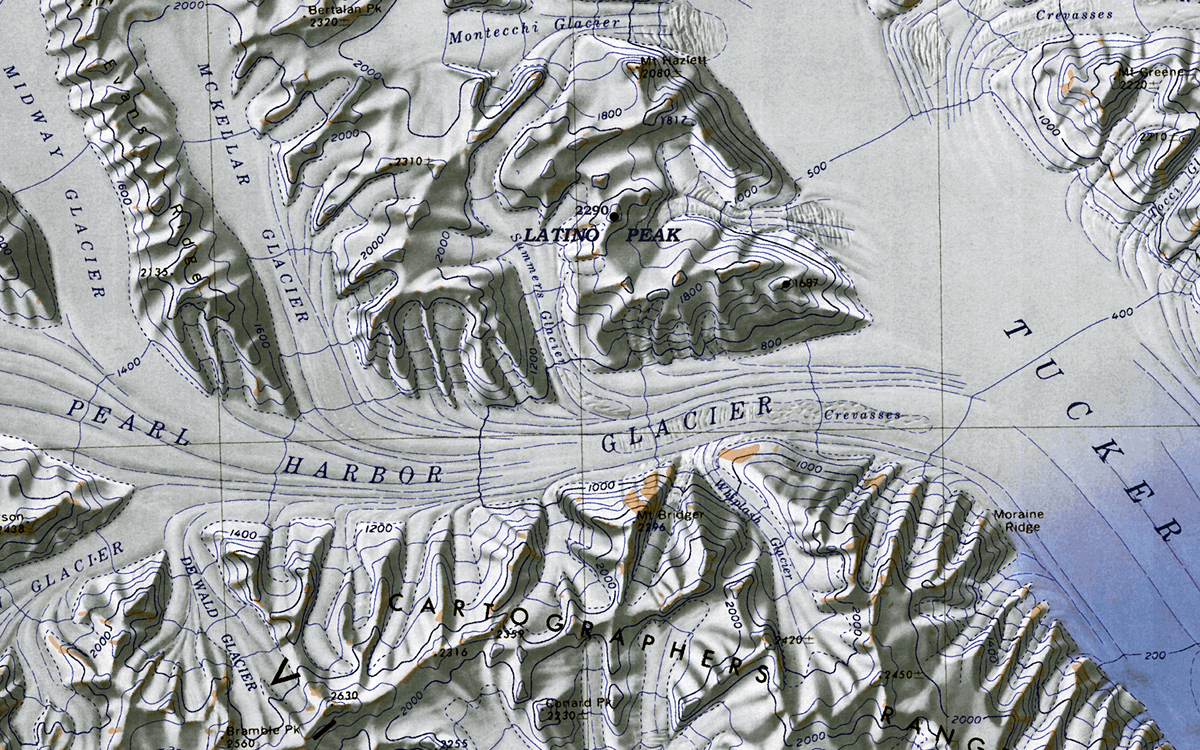
English: Map of Antarctica by the United States Antarctic Resource Center of the US Geological Society. |
| Dato | (UTC) |
| Kjelde |
This file was derived from: C72189s1 Ant.Map Cape Hallet.jpg: |
| Opphavsperson |
|
| This is a retouched picture, which means that it has been digitally altered from its original version. Modifications: cropped excerpt of "Latino Peak". The original can be viewed here: C72189s1 Ant.Map Cape Hallet.jpg:
|
Lisensiering:
This media file is in the public domain in the United States. This applies to U.S. works where the copyright has expired, often because its first publication occurred prior to January 1, 1929, and if not then due to lack of notice or renewal. See this page for further explanation.
|
 | |
 |
This image might not be in the public domain outside of the United States; this especially applies in the countries and areas that do not apply the rule of the shorter term for US works, such as Canada, Mainland China (not Hong Kong or Macao), Germany, Mexico, and Switzerland. The creator and year of publication are essential information and must be provided. See Wikipedia:Public domain and Wikipedia:Copyrights for more details.
|
Opphavleg opplastingslogg
This image is a derivative work of the following images:
- File:C72189s1_Ant.Map_Cape_Hallet.jpg licensed with PD-US
- 2005-04-03T17:40:20Z Achim Raschka 3860x3250 (2369572 Bytes) Map of Antarctica by the United States Antarctic Ressource Center of the US Geological Society. {{PD-US}} Copyrights and Trademarks USGS-authored or produced data and information are in the public domain. While the content o
Uploaded with derivativeFX
Filhistorikk
Klikk på dato/klokkeslett for å sjå fila slik ho var på det tidspunktet.
| Dato/klokkeslett | Miniatyrbilete | Oppløysing | Brukar | Kommentar | |
|---|---|---|---|---|---|
| gjeldande | 1. februar 2012 kl. 13:57 | | 1 200 × 750 (859 KB) | Oae448 | == {{int:filedesc}} == {{Information |Description=Map of Antarctica by the United States Antarctic Ressource Center of the US Geological Society. |Source={{Derived from|C72189s1_Ant.Map_Cape_Hallet.jpg|display=50}} |Date=2012-02-01 11:47 (UTC) |Author=*[[ |
Filbruk
Dei følgjande 5 sidene bruker denne fila:
Global filbruk
Desse andre wikiane nyttar fila:
- Bruk på ceb.wikipedia.org
- Bruk på en.wikipedia.org
- Bruk på he.wikipedia.org
- קרחון אלדר
- קרחון בייקר (אנטארקטיקה)
- פסגת אולדריג'
- הרי ויקטורי
- רכס קרטר
- פסגת בוס
- תבנית:הרי ויקטורי
- רכס בארקר
- קרחון קרול (אנטארקטיקה)
- קרחון טרפלגר
- קרחון טאקר
- רכס הנדלר
- הר ברוסטר (אנטארקטיקה)
- הר הרינגטון (ארץ ויקטוריה)
- קרחון וייטהול
- מפרצון טאקר
- הר נורת'האמפטון (אנטארקטיקה)
- קרחון באוורס
- אוכף טובוגאן
- פסגת ניו ייר (אנטארקטיקה)
- קרחון אינגהם
- קרחון המפריז
- קרחון בר
- קרחון הנד
- קרחון ליין
- קרחון לאנגוואד
- קרחון בארג
- קרחון בורשקרווינק (ארץ ויקטוריה)
- הר פיליפס (אנטארקטיקה)
- קרחון מרינר (אנטארקטיקה)
- רמת מלטה (אנטארקטיקה)
- נונאטאק נלסון (אנטארקטיקה)
- הר אלברטס
- קרחון פרל הארבור
- רכס קרטוגרפים
- קרחון אוסוגה
- הר ברטון (אנטארקטיקה)
- רכס קלאפ (אנטארקטיקה)
- קרחון הירפילד
- פסגת קולינס (אנטארקטיקה)
- קרחון קולסטון
- קרחון אולסון
- קרחון ווד (אנטארקטיקה)
- קרחון לנסן
- הר פירסון (אנטארקטיקה)
- הר מקדונלד (ארץ ויקטוריה)
- קרחון טריינר
Sjå meir global bruk av denne fila.