
Fil:NorthAmerica-WaterDivides.png

Storleik på førehandsvising: 600 × 600 pikslar. Andre oppløysingar: 240 × 240 pikslar | 480 × 480 pikslar | 900 × 900 pikslar.
Opphavleg fil (900 × 900 pikslar, filstorleik: 370 KB, MIME-type: image/png)
Følgjande er henta frå filomtalen åt denne fila på Wikimedia Commons:
Skildring
| Skildring |
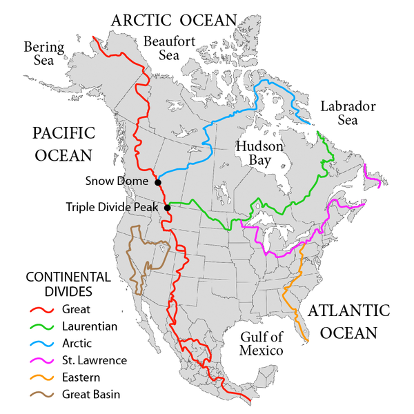
English: Map showing the major Continental divides of North America, following the style of File:NorthAmericaDivides.gif and intended as a replacement. Made using File:BlankMap-North America-Subdivisions.svg as a base map. Various maps and other sources consulted, such as: File:Ocean drainage.png, Drainage Basins, The Atlas of Canada, http://www.cec.org/atlas/files/watersheds/na_watersheds_en.jpg, and others. Note: the Eastern watershed boundary in the southern areas (orange line), and the St. Lawrence watershed boundary in the northern areas (magenta line) of this map more or less defined the Royal Proclamation's western boundaries. |
| Dato | |
| Kjelde | Eige arbeid |
| Opphavsperson | Pfly |
Lisensiering:
Eg, opphavsrettshaldaren til verket, publiserer det hermed under desse lisensane:
Denne fila er lisensiert under lisensen Creative Commons Namngjeving-DelPåSameVilkåra 3.0 Unported
- Du står fritt til å:
- til å dela – til å kopiera, distibuera og overføra arbeidet
- til å blanda – til å endra verket
- På desse vilkåra:
- namngjeving – Du lyt godskriva verket på den måten som opphavpersonen eller lisensgjevaren har oppgjeve (men ikkje på ein slik måte at det kan verka som om dei går god for deg eller måten du nyttar verket på).
- del på same vilkåra – Om du remiksar, omarbeider, eller på annan måte byggjer på dette verket, kan du berre distribuera resultatet under den same eller ein samsvarande lisens som denne.

|
Det er tillate å kopiera, distribuera og/eller modifisera dette dokumentet under retningslinene som er skildra i GNU fri dokumentasjonslisens, versjon 1.2 eller seinare utgåve utgjeven av Free Software Foundation; med alle seksjonane, utan nokon framsidetekstar og baksidetekstar. Ein kopi av lisensen er inkludert i avsnittet GNU Free Documentation License. |
Du kan velje den lisensen du sjølv tykkjer er best.
Filhistorikk
Klikk på dato/klokkeslett for å sjå fila slik ho var på det tidspunktet.
| Dato/klokkeslett | Miniatyrbilete | Oppløysing | Brukar | Kommentar | |
|---|---|---|---|---|---|
| gjeldande | 1. oktober 2019 kl. 04:47 | | 900 × 900 (370 KB) | Palaeozoic99 | Correct St. Lawrence |
| 22. november 2018 kl. 09:12 |  | 900 × 900 (440 KB) | Pfly | Try to remove transparency one more time, sigh | |
| 22. november 2018 kl. 08:51 |  | 900 × 900 (290 KB) | Pfly | Reverting to original with non-transparent background, as the transparency was displaying very badly, even unreadably, on mobile devices | |
| 22. november 2018 kl. 08:49 |  | 900 × 900 (256 KB) | Pfly | revert my own reversion--made mistake | |
| 22. november 2018 kl. 08:44 |  | 900 × 900 (290 KB) | Pfly | Reverted to version as of 21:09, 23 November 2010 (UTC): Transparent background looks very bad, even unreadable on mobile. | |
| 15. juli 2012 kl. 04:46 |  | 900 × 900 (256 KB) | Ubiquinoid | mildly updated: including names of oceans/seas in vicinity of North America (as displayed), per IHO | |
| 15. juli 2012 kl. 04:43 |  | 900 × 900 (256 KB) | Ubiquinoid | mildly updated: including names of oceans/seas in vicinity of North America (as displayed), per IHO | |
| 23. november 2010 kl. 23:09 |  | 900 × 900 (290 KB) | Pfly | {{Information |Description={{en|1=Map showing the major Continental divides of North America, following the style of File:NorthAmericaDivides.gif and intended as a replacement. Made using [[:File:BlankMap-North America-Subd |
Filbruk
Den følgjande sida bruker denne fila:
Global filbruk
Desse andre wikiane nyttar fila:
- Bruk på ar.wikipedia.org
- Bruk på cs.wikipedia.org
- Bruk på de.wikipedia.org
- Bruk på en.wikipedia.org
- North America
- List of rivers of the Americas
- Royal Proclamation of 1763
- Continental Divide of the Americas
- Rupert's Land
- Pigeon River (Minnesota–Ontario)
- Atlantic seaboard watershed
- Eastern Continental Divide
- Talk:Kensington Runestone
- Talk:List of lighthouses in the United States
- Great Divide Basin
- Central United States
- Triple Divide Peak (Montana)
- Chicago Portage
- Snow Dome (Canada)
- Hudson Bay drainage basin
- Geography of North America
- Laurentian Divide
- Continental divide
- Great Basin Divide
- Watersheds of North America
- Canadian canoe routes
- Voyageurs
- Pacific Slope
- Centennial Voyageur Canoe Pageant
- Triple divide
- St. Lawrence River Divide
- Timeline of Alberta history
- Bruk på en.wiktionary.org
- Bruk på eo.wikipedia.org
- Bruk på es.wikipedia.org
- Bruk på fr.wikipedia.org
- Bruk på hr.wikipedia.org
- Bruk på id.wikipedia.org
- Bruk på ig.wikipedia.org
- Bruk på it.wikipedia.org
Sjå meir global bruk av denne fila.