
Fil:ScotlandEastRenfrewshire.png
Høgare oppløysing er ikkje tilgjengeleg.
ScotlandEastRenfrewshire.png (200 × 230 pikslar, filstorleik: 4 KB, MIME-type: image/png)
Følgjande er henta frå filomtalen åt denne fila på Wikimedia Commons:
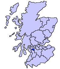
East Renfrewshire unitary council
Slightly edited version of a map drawn by Morwen

|
Det er tillate å kopiera, distribuera og/eller modifisera dette dokumentet under retningslinene som er skildra i GNU fri dokumentasjonslisens, versjon 1.2 eller seinare utgåve utgjeven av Free Software Foundation; med alle seksjonane, utan nokon framsidetekstar og baksidetekstar. Ein kopi av lisensen er inkludert i avsnittet GNU Free Documentation License. |
| Denne fila er lisensiert under lisensen Creative Commons Namngjeving-DelPåSameVilkåra 3.0 Unported | ||
| ||
| Dette lisensieringsmerket vart lagt til denne fila som ein del av GFDL-lisensieringsoppdateringa. |
Filhistorikk
Klikk på dato/klokkeslett for å sjå fila slik ho var på det tidspunktet.
| Dato/klokkeslett | Miniatyrbilete | Oppløysing | Brukar | Kommentar | |
|---|---|---|---|---|---|
| gjeldande | 17. mai 2005 kl. 23:34 | | 200 × 230 (4 KB) | Voyager | East Renfrewshire unitary council Slightly edited version of a map drawn by Morwen {{GFDL}} Category:Maps of Scottish unitary councils |
Filbruk
Den følgjande sida bruker denne fila:
Global filbruk
Desse andre wikiane nyttar fila:
- Bruk på be.wikipedia.org
- Bruk på bg.wikipedia.org
- Bruk på ca.wikipedia.org
- Bruk på cy.wikipedia.org
- Bruk på da.wikipedia.org
- Bruk på de.wikipedia.org
- Bruk på en.wikipedia.org
- Bruk på et.wikipedia.org
- Bruk på eu.wikipedia.org
- Ekialdeko Renfrewshire
- Lankide:Euskaldunaa
- Giffnock
- Newton Mearns
- Caldwell dorrea
- Txantiloi:Ekialdeko Renfrewshire
- Wikiproiektu:Irlanda, Gales eta Eskoziako udalerriak
- Barrhead
- Clarkston (Ekialdeko Renfrewshire)
- Busby (Ekialdeko Renfrewshire)
- Eaglesham
- Neilston
- Uplawmoor
- Waterfoot (Ekialdeko Renfrewshire)
- Shillford
- Arthurlie
- Muirend
- Netherlee
- Stamperland
- Thornliebank
- Bruk på ga.wikipedia.org
- Bruk på gv.wikipedia.org
- Bruk på no.wikipedia.org
- Bruk på pt.wikipedia.org
- Bruk på sv.wikipedia.org
- Bruk på uk.wikipedia.org
- Bruk på www.wikidata.org
- Bruk på zh-min-nan.wikipedia.org
- Bruk på zh.wikipedia.org