
Fil:Morrison Formation Brachiosauridae map.png

Storleik på førehandsvising: 627 × 600 pikslar. Andre oppløysingar: 251 × 240 pikslar | 502 × 480 pikslar | 803 × 768 pikslar | 1 071 × 1 024 pikslar | 2 540 × 2 429 pikslar.
Opphavleg fil (2 540 × 2 429 pikslar, filstorleik: 73 KB, MIME-type: image/png)
Følgjande er henta frå filomtalen åt denne fila på Wikimedia Commons:
Skildring
| Skildring |
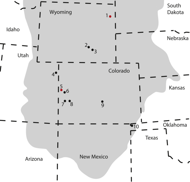
Map of occurrences of Brachiosauridae in the Upper Jurassic Morrison Formation. The locality of the pes described herein (1) and the type locality of Brachiosaurus altithorax (5) are highlighted in red. The gray area indicates the distribution of the Morrison Formation. 1, Bobcat Pit, Weston County, WY; 2, Freezeout Hills general, Carbon Co., WY; 3, Reed’s Quarry 13, Albany Co., WY; 4, Jensen/Jensen Quarry, Uintah Co., UT; 5, Fruita Paleontological Area general, Mesa Co., CO; 6, Riggs Quarry 13, Mesa Co., CO; 7, Dry Mesa Quarry, Mesa Co., CO; 8, Potter Creek Quarry, Montrose Co., CO; 9, Felch Quarry 1, Fremont Co., CO; 10, Kenton Pit 1, Cimarron Co., OK. Modified from Bonnan & Wedel (2004: fig. 2). |
| Dato | |
| Kjelde | https://peerj.com/articles/5250/ |
| Opphavsperson | Anthony Maltese, Emanuel Tschopp, Femke Holwerda, David Burnham |
| Løyve (Gjenbruk av denne fila) |
https://peerj.com/articles/5250.pdf |
Lisensiering:
Denne fila er lisensiert under lisensen Creative Commons Namngjeving 4.0 internasjonal.
- Du står fritt til å:
- til å dela – til å kopiera, distibuera og overføra arbeidet
- til å blanda – til å endra verket
- På desse vilkåra:
- namngjeving – Du lyt godskriva verket på den måten som opphavpersonen eller lisensgjevaren har oppgjeve (men ikkje på ein slik måte at det kan verka som om dei går god for deg eller måten du nyttar verket på).
Denne fila, som vart opphavleg lagd ut på https://peerj.com/articles/5250/, vart gjennomgått 24. juli 2018 av administratoren eller lisensrøktaren Guanaco, som stadfeste at fila var tilgjengeleg på URL-en under den gjevne lisensen på denne datoen.
|
Filhistorikk
Klikk på dato/klokkeslett for å sjå fila slik ho var på det tidspunktet.
| Dato/klokkeslett | Miniatyrbilete | Oppløysing | Brukar | Kommentar | |
|---|---|---|---|---|---|
| gjeldande | 10. august 2018 kl. 19:09 | | 2 540 × 2 429 (73 KB) | HerrAdams | Cropped 1 % horizontally, 1 % vertically using CropTool with precise mode. Removed border. |
| 24. juli 2018 kl. 22:17 |  | 2 571 × 2 460 (111 KB) | FunkMonk | == {{int:filedesc}} == {{Information |description=Map of occurrences of Brachiosauridae in the Upper Jurassic Morrison Formation. The locality of the pes described herein (1) and the type locality of Brachiosaurus altithorax (5) are highlighted in red. The gray area indicates the distribution of the Morrison Formation. 1, Bobcat Pit, Weston County, WY; 2, Freezeout Hills general, Carbon Co., WY; 3, Reed’s Quarry 13, Albany Co., WY; 4, Jensen/Jensen Quarry, Uintah Co., UT; 5, Fruita Paleontolo... |
Filbruk
Den følgjande sida bruker denne fila:
Global filbruk
Desse andre wikiane nyttar fila:
- Bruk på ar.wikipedia.org
- Bruk på ast.wikipedia.org
- Bruk på bg.wikipedia.org
- Bruk på ca.wikipedia.org
- Bruk på cs.wikipedia.org
- Bruk på en.wikipedia.org
- Bruk på eu.wikipedia.org
- Bruk på he.wikipedia.org
- Bruk på hr.wikipedia.org
- Bruk på hu.wikipedia.org
- Bruk på mk.wikipedia.org
- Bruk på pl.wikipedia.org
- Bruk på sv.wikipedia.org
- Bruk på tr.wikipedia.org
- Bruk på www.wikidata.org
- Bruk på zh.wikipedia.org