Alexandra Mountains
| Alexandra Mountains | |||
| fjellkjede | |||
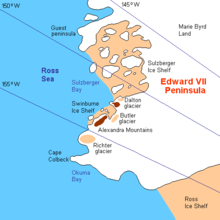
Kart over området kring Guest Peninsula.
| |||
| Land | |||
|---|---|---|---|
| Stad | King Edward VII Land | ||
| - koordinatar | 77°25′S 153°30′W / 77.417°S 153.500°W | ||
| Administrert under | Antarktistraktaten | ||
 Alexandra Mountains 77°25′00″S 153°30′00″W / 77.41666667°S 153.5°W | |||
Alexandra Mountains er ei gruppe låge, spreidde fjell nord på Edward VII Peninsula, like sørvest for Sulzberger Bay i Marie Byrd Land i Antarktis. Det vart oppdaga i januar-februar 1902 av Discovery-ekspedisjonen i løpet av ein utforskingssegla med «Discovery» langs Rossisen. Fjellkjeda er kalla opp etter Alexandra, då dronning av Storbritannia.[1]
Fjell[endre | endre wikiteksten]
- Balsley Peak er eit fjell (ca 1100 moh) som ligg 2,6 km søraust for La Gorce Peak. Ho vart namngjeven av Advisory Committee on Antarctic Names (US-ACAN) (2004) etter James R. Balsley, U.S. Geological Survey, som utførte magnetometer-målingar frå fly nær denne toppen i løpet av U.S. Navy Operasjon Highjump, 1946-47.[2]
- Bowman Peak er ein fjelltopp på sørsida av Butlerbreen i Alexandra Mountains. Det vart oppdaga av Byrd-ekspedisjonen i 1929 og kalla opp etter John McEntee Bowman, direktør i Bowman-Biltmore Hotels Corporation, som donerte hovudkvarter for førebuinga av ekspedisjonen.[3]
- Mount Josephine er eit fjell med markante steinutspring, 10 km søraust for Bowman Peak. Det vart oppdaga av kontreadmiral Byrd under Byrd-ekspedisjonen den 5. desember 1929, og vart namngjeven av han i løpet av Byrd-ekspedisjonen (1933-35) etter Josephine Clay Ford, dotter til Edsel Ford, som støtta ekspedisjonane.[4]
- La Gorce Peak er eit markant fjell 13 km sørvest for Mount Josephine og er det høgaste fjellet i Alexandra Mountains. Det ligg heilt sør i fjellkjeda. Det vart oppdaga i februar 1929 av Byrd-ekspedisjonen, og vart namngjeven av Byrd etter John Oliver La Gorce.[5]
- Scott Nunataks er eit kjenneleg fjell heilt nord i Alexandra Mountains. Det vart oppdaga i 1902 av Discovery-ekspedisjonen under kaptein Robert F. Scott og kalla opp etter Scott av løytnant Kristian Prestrud, leiaren for det austlege sledelaget under Sørpolekspedisjonen til Amundsen som gjekk til topps på dette fjellet då dei utforska Edward VII Peninsula i 1911.[6]
- Sneddon Nunataks er ei gruppe nunatakar ved kysten på nordsida av Edward VII Peninsula ovanom Swinburne isbrem og Sulzberger Bay. Dei står 17 km søraust for Scott Nunataks nord i Alexandra Mountains. Nunatakane finst på eit kart frå Byrd-ekspedisjonen, 1928-30. Dei vart namngjevne av US-ACAN etter Donald L. Sneddon i US Navy, som var elektrikar på Byrd-stasjonen vinteren i 1967.[7]
- Mount Youngman er eit snødekt fjell (620 moh) på kysten, 6,5 km søraust for Scott Nunataks. Det står ved Cumbiebreen ovanom Swinburne isbrem og Sulzberger Bay som ligg like nord. Fjellet vart først kartlagd av US Geological Survey (USGS) frå landmålingar og flyfoto tekne av U.S. Navy, 1964-66. Ho vart namngjeven av Advisory Committee on Antarctic Names (US-ACAN) etter kaptein Samuel A. Youngman i US Navy, militærlege på «Commander», eit skip nytta under Operasjon Deep Freeze 1969 og 1970.[8]
Kjelder[endre | endre wikiteksten]
- Denne artikkelen bygger på «Alexandra Mountains» frå Wikipedia på engelsk, den 28. februar 2013.
- Wikipedia på engelsk oppgav desse kjeldene:
 Denne artikkelen inneheld stoff som er offentleg eige frå United States Geological Survey-artikkelen «Alexandra Mountains» (innhald frå Geographic Names Information System).
- ↑ «Alexandra Mountains». Geographic Names Information System. United States Geological Survey, United States Department of the Interior. Henta 27. februar 2013.
- ↑ «Balsley Peak». Geographic Names Information System. United States Geological Survey, United States Department of the Interior. Henta 26. februar 2013.
- ↑ «Bowman Peak». Geographic Names Information System. United States Geological Survey, United States Department of the Interior. Henta 25. februar 2013.
- ↑ «Mount Josephine». Geographic Names Information System. United States Geological Survey, United States Department of the Interior. Henta 28. februar 2013.
- ↑ «La Gorce Peak». Geographic Names Information System. United States Geological Survey, United States Department of the Interior. Henta 28. februar 2013.
- ↑ «Scott Nunataks». Geographic Names Information System. United States Geological Survey, United States Department of the Interior. Henta 28. februar 2013.
- ↑ «Sneddon Nunataks». Geographic Names Information System. United States Geological Survey, United States Department of the Interior. Henta 28. februar 2013.
- ↑ «Mount Youngman». Geographic Names Information System. United States Geological Survey, United States Department of the Interior. Henta 28. februar 2013.


